You are here: Home > Network List > TA - USArray Transportable Network (new EarthScope stations) Stations List
> Station Q17K Contact Creek, Katmai, AK, USA > Earthquake Result Viewer
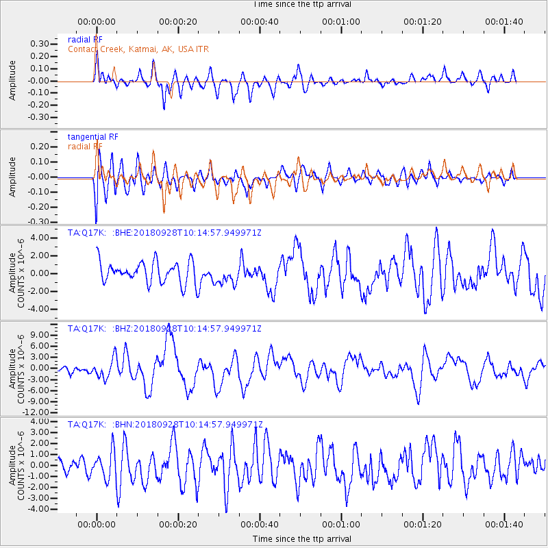
Q17K Contact Creek, Katmai, AK, USA - Earthquake Result Viewer
*The percent match for this event was below the threshold and hence no stack was calculated.
| Earthquake location: |
Minahassa Peninsula, Sulawesi |
| Earthquake latitude/longitude: |
-0.2/119.8 |
| Earthquake time(UTC): |
2018/09/28 (271) 10:02:43 GMT |
| Earthquake Depth: |
10 km |
| Earthquake Magnitude: |
7.5 Mww |
| Earthquake Catalog/Contributor: |
NEIC PDE/us |
|
| Network: |
TA USArray Transportable Network (new EarthScope stations) |
| Station: |
Q17K Contact Creek, Katmai, AK, USA |
| Lat/Lon: |
58.26 N/155.89 W |
| Elevation: |
1165 m |
|
| Distance: |
87.1 deg |
| Az: |
31.775 deg |
| Baz: |
265.041 deg |
| Ray Param: |
$rayparam |
*The percent match for this event was below the threshold and hence was not used in the summary stack. |
|
| Radial Match: |
76.9167 % |
| Radial Bump: |
400 |
| Transverse Match: |
68.73171 % |
| Transverse Bump: |
400 |
| SOD ConfigId: |
13570011 |
| Insert Time: |
2019-05-01 08:53:11.902 +0000 |
| GWidth: |
2.5 |
| Max Bumps: |
400 |
| Tol: |
0.001 |
|
Signal To Noise
| Channel | StoN | STA | LTA |
| TA:Q17K: :BHZ:20180928T10:14:57.949971Z | 2.0595937 | 2.741705E-6 | 1.3311873E-6 |
| TA:Q17K: :BHN:20180928T10:14:57.949971Z | 1.1693648 | 1.2683913E-6 | 1.0846841E-6 |
| TA:Q17K: :BHE:20180928T10:14:57.949971Z | 0.9108559 | 1.0916332E-6 | 1.1984697E-6 |
| Arrivals |
| Ps | |
| PpPs | |
| PsPs/PpSs | |


