You are here: Home > Network List > TA - USArray Transportable Network (new EarthScope stations) Stations List
> Station R32K Eaglecrest, AK, USA > Earthquake Result Viewer
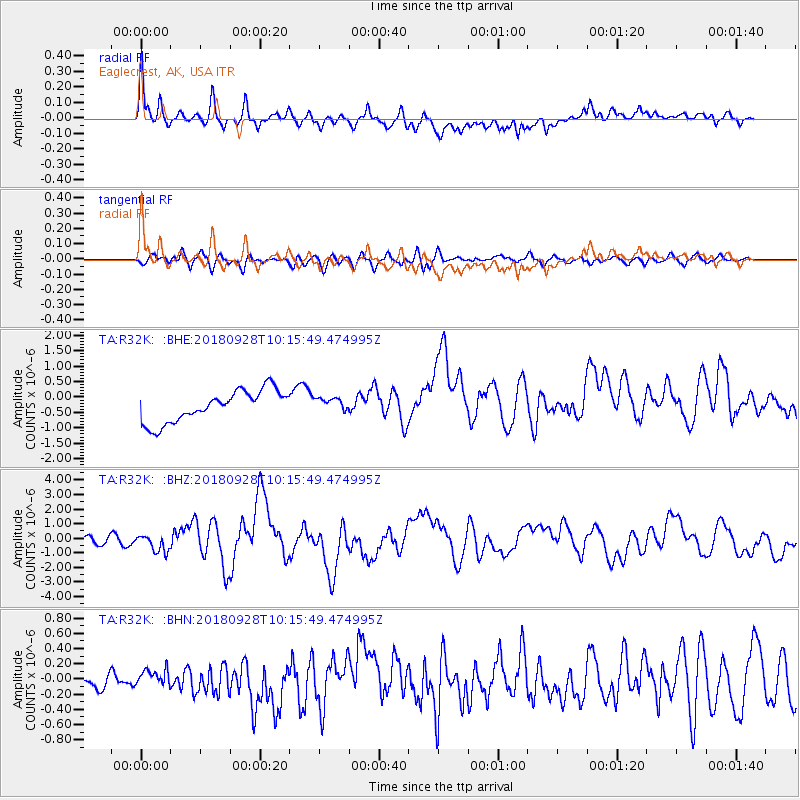
R32K Eaglecrest, AK, USA - Earthquake Result Viewer
*The percent match for this event was below the threshold and hence no stack was calculated.
| Earthquake location: |
Minahassa Peninsula, Sulawesi |
| Earthquake latitude/longitude: |
-0.2/119.8 |
| Earthquake time(UTC): |
2018/09/28 (271) 10:02:43 GMT |
| Earthquake Depth: |
10 km |
| Earthquake Magnitude: |
7.5 Mww |
| Earthquake Catalog/Contributor: |
NEIC PDE/us |
|
| Network: |
TA USArray Transportable Network (new EarthScope stations) |
| Station: |
R32K Eaglecrest, AK, USA |
| Lat/Lon: |
58.27 N/134.52 W |
| Elevation: |
386 m |
|
| Distance: |
98.3 deg |
| Az: |
30.949 deg |
| Baz: |
283.28 deg |
| Ray Param: |
$rayparam |
*The percent match for this event was below the threshold and hence was not used in the summary stack. |
|
| Radial Match: |
77.54844 % |
| Radial Bump: |
400 |
| Transverse Match: |
75.92275 % |
| Transverse Bump: |
400 |
| SOD ConfigId: |
13570011 |
| Insert Time: |
2019-05-01 08:53:13.804 +0000 |
| GWidth: |
2.5 |
| Max Bumps: |
400 |
| Tol: |
0.001 |
|
Signal To Noise
| Channel | StoN | STA | LTA |
| TA:R32K: :BHZ:20180928T10:15:49.474995Z | 3.6406727 | 6.21575E-7 | 1.7073081E-7 |
| TA:R32K: :BHN:20180928T10:15:49.474995Z | 0.63288474 | 9.24253E-8 | 1.4603812E-7 |
| TA:R32K: :BHE:20180928T10:15:49.474995Z | 0.43192893 | 2.2004492E-7 | 5.0944703E-7 |
| Arrivals |
| Ps | |
| PpPs | |
| PsPs/PpSs | |


