You are here: Home > Network List > TJ - Tajikistan National Seismic Network Stations List
> Station GARM Garm, Tajikistan > Earthquake Result Viewer
GARM Garm, Tajikistan - Earthquake Result Viewer
| Earthquake location: |
Minahassa Peninsula, Sulawesi |
| Earthquake latitude/longitude: |
-0.2/119.8 |
| Earthquake time(UTC): |
2018/09/28 (271) 10:02:43 GMT |
| Earthquake Depth: |
10 km |
| Earthquake Magnitude: |
7.5 Mww |
| Earthquake Catalog/Contributor: |
NEIC PDE/us |
|
| Network: |
TJ Tajikistan National Seismic Network |
| Station: |
GARM Garm, Tajikistan |
| Lat/Lon: |
39.00 N/70.32 E |
| Elevation: |
1305 m |
|
| Distance: |
59.7 deg |
| Az: |
316.67 deg |
| Baz: |
118.281 deg |
| Ray Param: |
0.06198732 |
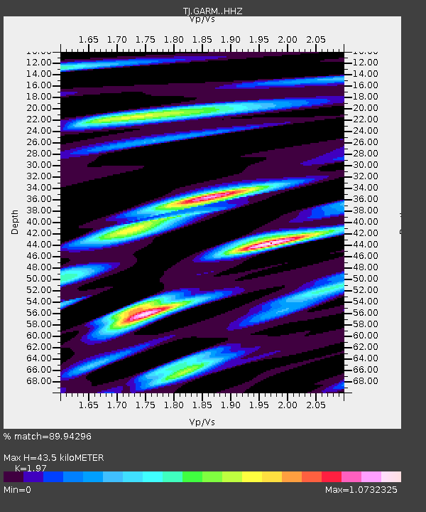
| Estimated Moho Depth: |
43.5 km |
| Estimated Crust Vp/Vs: |
1.97 |
| Assumed Crust Vp: |
6.306 km/s |
| Estimated Crust Vs: |
3.201 km/s |
| Estimated Crust Poisson's Ratio: |
0.33 |
|
| Radial Match: |
89.94296 % |
| Radial Bump: |
400 |
| Transverse Match: |
87.8396 % |
| Transverse Bump: |
400 |
| SOD ConfigId: |
13570011 |
| Insert Time: |
2019-05-01 08:53:18.116 +0000 |
| GWidth: |
2.5 |
| Max Bumps: |
400 |
| Tol: |
0.001 |
|
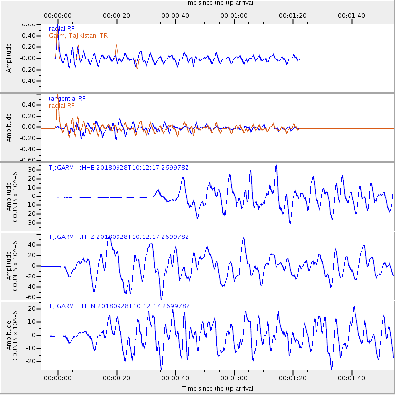
Signal To Noise
| Channel | StoN | STA | LTA |
| TJ:GARM: :HHZ:20180928T10:12:17.269978Z | 48.718655 | 9.255141E-6 | 1.8997119E-7 |
| TJ:GARM: :HHN:20180928T10:12:17.269978Z | 24.596846 | 2.1989147E-6 | 8.939824E-8 |
| TJ:GARM: :HHE:20180928T10:12:17.269978Z | 26.044739 | 3.7276147E-6 | 1.4312353E-7 |
| Arrivals |
| Ps | 7.0 SECOND |
| PpPs | 20 SECOND |
| PsPs/PpSs | 27 SECOND |


