You are here: Home > Network List > TA - USArray Transportable Network (new EarthScope stations) Stations List
> Station U15A North Rim, AZ, USA > Earthquake Result Viewer
U15A North Rim, AZ, USA - Earthquake Result Viewer
| Earthquake location: |
Santa Cruz Islands |
| Earthquake latitude/longitude: |
-12.6/166.0 |
| Earthquake time(UTC): |
2009/10/07 (280) 23:23:28 GMT |
| Earthquake Depth: |
36 km |
| Earthquake Magnitude: |
5.5 MB |
| Earthquake Catalog/Contributor: |
WHDF/NEIC |
|
| Network: |
TA USArray Transportable Network (new EarthScope stations) |
| Station: |
U15A North Rim, AZ, USA |
| Lat/Lon: |
36.43 N/112.29 W |
| Elevation: |
2489 m |
|
| Distance: |
90.8 deg |
| Az: |
52.963 deg |
| Baz: |
255.098 deg |
| Ray Param: |
0.041639585 |
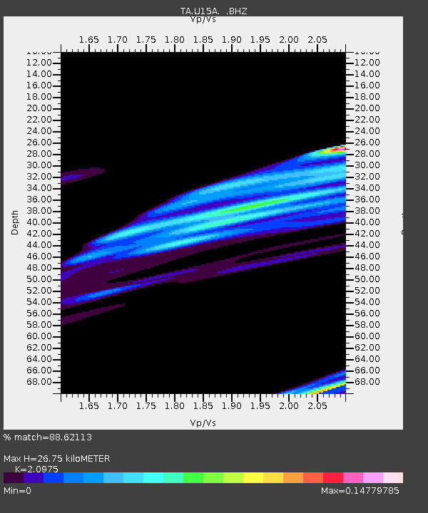
| Estimated Moho Depth: |
26.75 km |
| Estimated Crust Vp/Vs: |
2.10 |
| Assumed Crust Vp: |
6.194 km/s |
| Estimated Crust Vs: |
2.953 km/s |
| Estimated Crust Poisson's Ratio: |
0.35 |
|
| Radial Match: |
88.62113 % |
| Radial Bump: |
399 |
| Transverse Match: |
85.68519 % |
| Transverse Bump: |
350 |
| SOD ConfigId: |
2622 |
| Insert Time: |
2010-03-06 16:19:32.689 +0000 |
| GWidth: |
2.5 |
| Max Bumps: |
400 |
| Tol: |
0.001 |
|

Signal To Noise
| Channel | StoN | STA | LTA |
| TA:U15A: :BHZ:20091007T23:35:56.974019Z | 1.5822394 | 3.2170206E-5 | 2.0332072E-5 |
| TA:U15A: :BHN:20091007T23:35:56.974019Z | 1.7491423 | 1.30382405E-5 | 7.4540762E-6 |
| TA:U15A: :BHE:20091007T23:35:56.974019Z | 0.84683436 | 2.0864538E-5 | 2.4638273E-5 |
| Arrivals |
| Ps | 4.8 SECOND |
| PpPs | 13 SECOND |
| PsPs/PpSs | 18 SECOND |


