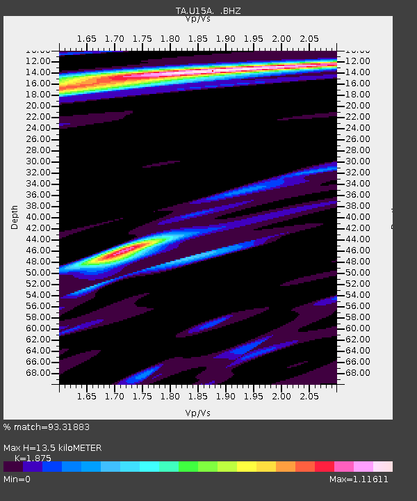
U15A North Rim, AZ, USA - Earthquake Result Viewer

Earthquake location: Fox Islands, Aleutian Islands
Earthquake latitude/longitude: 52.8/-167.0
Earthquake time(UTC): 2009/10/13 (286) 05:37:23 GMT
Earthquake Depth: 24 km
Earthquake Magnitude: 6.0 MB, 6.1 MS, 6.5 MW, 6.5 MW
Earthquake Catalog/Contributor: WHDF/NEIC
Network: TA USArray Transportable Network (new EarthScope stations)
Station: U15A North Rim, AZ, USA
Lat/Lon: 36.43 N/112.29 W
Elevation: 2489 m
Distance: 41.2 deg
Az: 90.929 deg
Baz: 311.102 deg
Ray Param: 0.07391859
Estimated Moho Depth: 13.5 km
Estimated Crust Vp/Vs: 1.88
Assumed Crust Vp: 6.194 km/s
Estimated Crust Vs: 3.304 km/s
Estimated Crust Poisson's Ratio: 0.30
Radial Match: 93.31883 %
Radial Bump: 400
Transverse Match: 76.416275 %
Transverse Bump: 400
SOD ConfigId: 2622
Insert Time: 2010-03-06 16:19:37.070 +0000
GWidth: 2.5
Max Bumps: 400
Tol: 0.001

Signal To Noise

ChannelStoNSTALTA
TA:U15A: :BHZ:20091013T05:44:35.424009Z2.76670534.5548086E-71.6462933E-7
TA:U15A: :BHN:20091013T05:44:35.424009Z0.73545481.4870821E-72.0219899E-7
TA:U15A: :BHE:20091013T05:44:35.424009Z0.81984861.5097353E-71.8414806E-7
Arrivals
Ps2.0 SECOND
PpPs5.9 SECOND
PsPs/PpSs7.9 SECOND