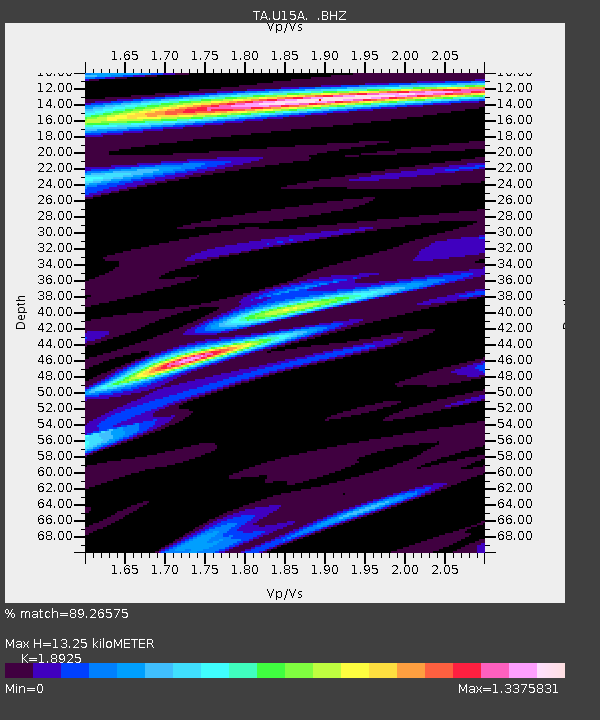
U15A North Rim, AZ, USA - Earthquake Result Viewer

Earthquake location: Fox Islands, Aleutian Islands
Earthquake latitude/longitude: 52.6/-167.1
Earthquake time(UTC): 2009/10/13 (286) 20:21:53 GMT
Earthquake Depth: 14 km
Earthquake Magnitude: 5.9 MB, 6.4 MS, 6.4 MW, 6.4 MW
Earthquake Catalog/Contributor: WHDF/NEIC
Network: TA USArray Transportable Network (new EarthScope stations)
Station: U15A North Rim, AZ, USA
Lat/Lon: 36.43 N/112.29 W
Elevation: 2489 m
Distance: 41.2 deg
Az: 90.66 deg
Baz: 310.872 deg
Ray Param: 0.07390226
Estimated Moho Depth: 13.25 km
Estimated Crust Vp/Vs: 1.89
Assumed Crust Vp: 6.194 km/s
Estimated Crust Vs: 3.273 km/s
Estimated Crust Poisson's Ratio: 0.31
Radial Match: 89.26575 %
Radial Bump: 400
Transverse Match: 67.01884 %
Transverse Bump: 400
SOD ConfigId: 2622
Insert Time: 2010-03-06 16:19:38.760 +0000
GWidth: 2.5
Max Bumps: 400
Tol: 0.001

Signal To Noise

ChannelStoNSTALTA
TA:U15A: :BHZ:20091013T20:29:06.825Z5.85214765.2844166E-79.0298755E-8
TA:U15A: :BHN:20091013T20:29:06.825Z1.39598812.6109907E-71.870353E-7
TA:U15A: :BHE:20091013T20:29:06.825Z2.5521324.3993631E-71.7237994E-7
Arrivals
Ps2.0 SECOND
PpPs5.8 SECOND
PsPs/PpSs7.9 SECOND