You are here: Home > Network List > TA - USArray Transportable Network (new EarthScope stations) Stations List
> Station U15A North Rim, AZ, USA > Earthquake Result Viewer
U15A North Rim, AZ, USA - Earthquake Result Viewer
| Earthquake location: |
Windward Islands |
| Earthquake latitude/longitude: |
15.0/-61.3 |
| Earthquake time(UTC): |
2007/11/29 (333) 19:00:19 GMT |
| Earthquake Depth: |
148 km |
| Earthquake Magnitude: |
6.9 MB, 7.4 MW, 7.4 MW |
| Earthquake Catalog/Contributor: |
WHDF/NEIC |
|
| Network: |
TA USArray Transportable Network (new EarthScope stations) |
| Station: |
U15A North Rim, AZ, USA |
| Lat/Lon: |
36.43 N/112.29 W |
| Elevation: |
2489 m |
|
| Distance: |
50.1 deg |
| Az: |
305.13 deg |
| Baz: |
101.459 deg |
| Ray Param: |
0.06778428 |
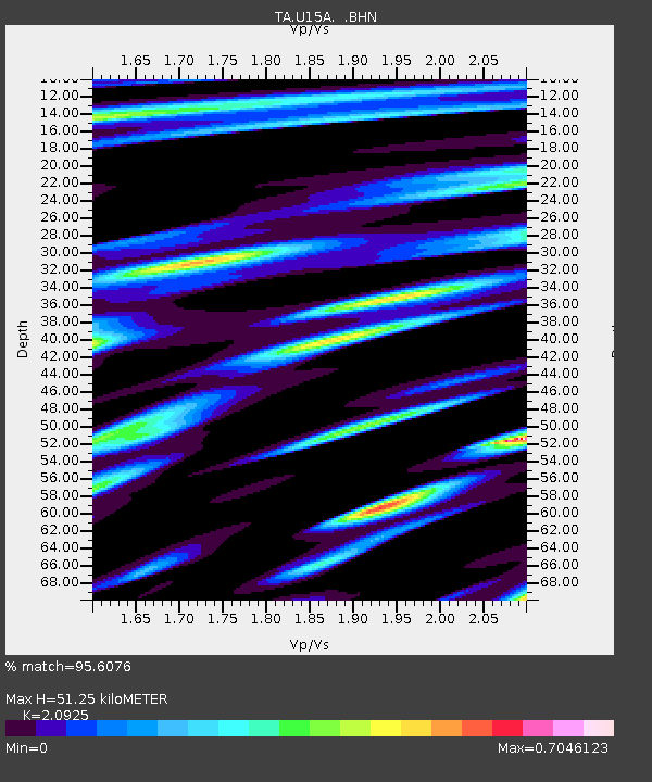
| Estimated Moho Depth: |
51.25 km |
| Estimated Crust Vp/Vs: |
2.09 |
| Assumed Crust Vp: |
6.194 km/s |
| Estimated Crust Vs: |
2.96 km/s |
| Estimated Crust Poisson's Ratio: |
0.35 |
|
| Radial Match: |
95.6076 % |
| Radial Bump: |
400 |
| Transverse Match: |
94.47889 % |
| Transverse Bump: |
400 |
| SOD ConfigId: |
2564 |
| Insert Time: |
2010-03-06 16:19:49.176 +0000 |
| GWidth: |
2.5 |
| Max Bumps: |
400 |
| Tol: |
0.001 |
|

Signal To Noise
| Channel | StoN | STA | LTA |
| TA:U15A: :BHN:20071129T19:08:28.775Z | 3.9228666 | 6.4145115E-7 | 1.6351592E-7 |
| TA:U15A: :BHE:20071129T19:08:28.775Z | 9.061866 | 3.0058777E-6 | 3.3170625E-7 |
| TA:U15A: :BHZ:20071129T19:08:28.775Z | 20.161594 | 6.2962476E-6 | 3.122892E-7 |
| Arrivals |
| Ps | 9.5 SECOND |
| PpPs | 24 SECOND |
| PsPs/PpSs | 34 SECOND |


