You are here: Home > Network List > CN - Canadian National Seismograph Network Stations List
> Station INK INUVIK, NT > Earthquake Result Viewer
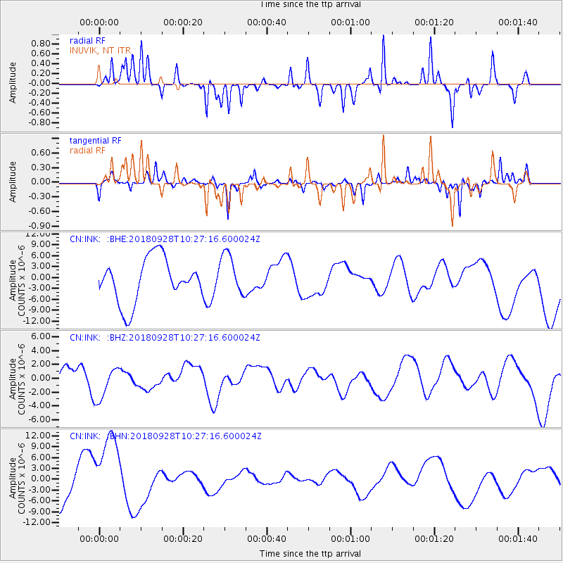
INK INUVIK, NT - Earthquake Result Viewer
*The percent match for this event was below the threshold and hence no stack was calculated.
| Earthquake location: |
Minahassa Peninsula, Sulawesi |
| Earthquake latitude/longitude: |
0.0/119.8 |
| Earthquake time(UTC): |
2018/09/28 (271) 10:14:20 GMT |
| Earthquake Depth: |
10 km |
| Earthquake Magnitude: |
5.8 mb |
| Earthquake Catalog/Contributor: |
NEIC PDE/us |
|
| Network: |
CN Canadian National Seismograph Network |
| Station: |
INK INUVIK, NT |
| Lat/Lon: |
68.31 N/133.53 W |
| Elevation: |
44 m |
|
| Distance: |
96.1 deg |
| Az: |
20.985 deg |
| Baz: |
285.581 deg |
| Ray Param: |
$rayparam |
*The percent match for this event was below the threshold and hence was not used in the summary stack. |
|
| Radial Match: |
37.84186 % |
| Radial Bump: |
176 |
| Transverse Match: |
59.70324 % |
| Transverse Bump: |
227 |
| SOD ConfigId: |
13570011 |
| Insert Time: |
2019-05-01 08:55:21.421 +0000 |
| GWidth: |
2.5 |
| Max Bumps: |
400 |
| Tol: |
0.001 |
|
Signal To Noise
| Channel | StoN | STA | LTA |
| CN:INK: :BHZ:20180928T10:27:16.600024Z | 1.065559 | 2.4956444E-6 | 2.3420987E-6 |
| CN:INK: :BHN:20180928T10:27:16.600024Z | 2.8823678 | 1.0796827E-5 | 3.7458185E-6 |
| CN:INK: :BHE:20180928T10:27:16.600024Z | 0.9698745 | 5.772626E-6 | 5.951931E-6 |
| Arrivals |
| Ps | |
| PpPs | |
| PsPs/PpSs | |


