You are here: Home > Network List > TS - TERRAscope (Southern California Seismic Network) Stations List
> Station BAR Barrett Dam, California, USA > Earthquake Result Viewer
BAR Barrett Dam, California, USA - Earthquake Result Viewer
| Earthquake location: |
Hokkaido, Japan Region |
| Earthquake latitude/longitude: |
42.0/139.9 |
| Earthquake time(UTC): |
1993/08/07 (219) 19:42:43 GMT |
| Earthquake Depth: |
26 km |
| Earthquake Magnitude: |
6.2 MB, 6.0 MS, 5.6 UNKNOWN, 6.3 MW |
| Earthquake Catalog/Contributor: |
WHDF/NEIC |
|
| Network: |
TS TERRAscope (Southern California Seismic Network) |
| Station: |
BAR Barrett Dam, California, USA |
| Lat/Lon: |
32.68 N/116.67 W |
| Elevation: |
548 m |
|
| Distance: |
77.8 deg |
| Az: |
57.048 deg |
| Baz: |
312.086 deg |
| Ray Param: |
0.050050013 |
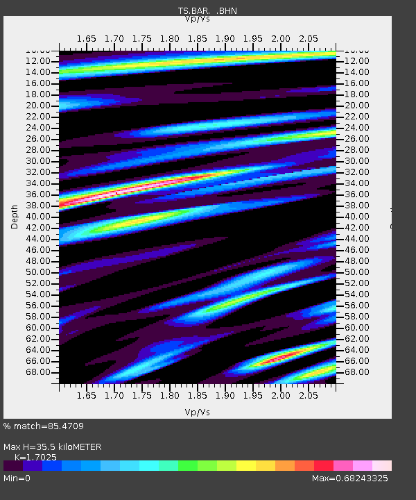
| Estimated Moho Depth: |
35.5 km |
| Estimated Crust Vp/Vs: |
1.70 |
| Assumed Crust Vp: |
6.264 km/s |
| Estimated Crust Vs: |
3.679 km/s |
| Estimated Crust Poisson's Ratio: |
0.24 |
|
| Radial Match: |
85.4709 % |
| Radial Bump: |
400 |
| Transverse Match: |
83.66516 % |
| Transverse Bump: |
400 |
| SOD ConfigId: |
16938 |
| Insert Time: |
2010-02-26 13:57:14.710 +0000 |
| GWidth: |
2.5 |
| Max Bumps: |
400 |
| Tol: |
0.001 |
|
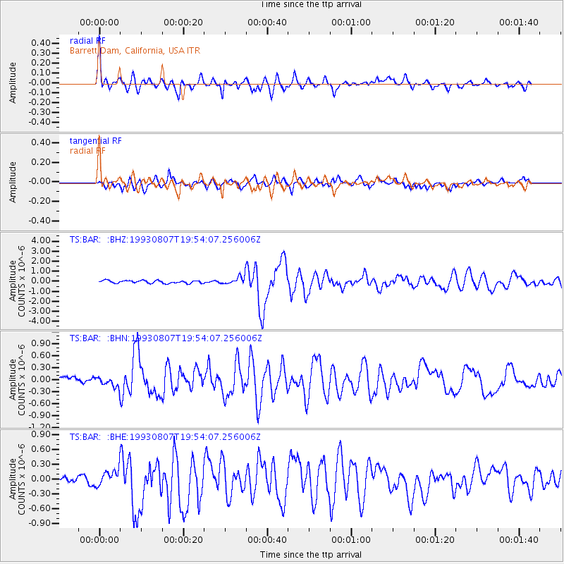
Signal To Noise
| Channel | StoN | STA | LTA |
| TS:BAR: :BHN:19930807T19:54:07.256006Z | 0.9138693 | 1.1945752E-7 | 1.3071619E-7 |
| TS:BAR: :BHE:19930807T19:54:07.256006Z | 1.9844496 | 1.6205118E-7 | 8.166052E-8 |
| TS:BAR: :BHZ:19930807T19:54:07.256006Z | 3.071144 | 4.0931357E-7 | 1.3327723E-7 |
| Arrivals |
| Ps | 4.1 SECOND |
| PpPs | 15 SECOND |
| PsPs/PpSs | 19 SECOND |


