You are here: Home > Network List > TA - USArray Transportable Network (new EarthScope stations) Stations List
> Station U15A North Rim, AZ, USA > Earthquake Result Viewer
U15A North Rim, AZ, USA - Earthquake Result Viewer
| Earthquake location: |
Tonga Islands |
| Earthquake latitude/longitude: |
-17.5/-174.3 |
| Earthquake time(UTC): |
2007/08/26 (238) 12:37:31 GMT |
| Earthquake Depth: |
127 km |
| Earthquake Magnitude: |
5.9 MB, 6.1 MW |
| Earthquake Catalog/Contributor: |
WHDF/NEIC |
|
| Network: |
TA USArray Transportable Network (new EarthScope stations) |
| Station: |
U15A North Rim, AZ, USA |
| Lat/Lon: |
36.43 N/112.29 W |
| Elevation: |
2489 m |
|
| Distance: |
79.4 deg |
| Az: |
46.456 deg |
| Baz: |
239.079 deg |
| Ray Param: |
0.048714235 |
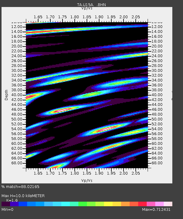
| Estimated Moho Depth: |
10.0 km |
| Estimated Crust Vp/Vs: |
1.60 |
| Assumed Crust Vp: |
6.194 km/s |
| Estimated Crust Vs: |
3.871 km/s |
| Estimated Crust Poisson's Ratio: |
0.18 |
|
| Radial Match: |
88.02165 % |
| Radial Bump: |
400 |
| Transverse Match: |
85.22398 % |
| Transverse Bump: |
400 |
| SOD ConfigId: |
2564 |
| Insert Time: |
2010-03-06 16:20:03.883 +0000 |
| GWidth: |
2.5 |
| Max Bumps: |
400 |
| Tol: |
0.001 |
|

Signal To Noise
| Channel | StoN | STA | LTA |
| TA:U15A: :BHN:20070826T12:48:51.924009Z | 3.3411086 | 2.2431841E-7 | 6.713892E-8 |
| TA:U15A: :BHE:20070826T12:48:51.924009Z | 4.25912 | 3.6641E-7 | 8.60295E-8 |
| TA:U15A: :BHZ:20070826T12:48:51.924009Z | 15.309616 | 1.2237027E-6 | 7.993034E-8 |
| Arrivals |
| Ps | 1.0 SECOND |
| PpPs | 4.1 SECOND |
| PsPs/PpSs | 5.1 SECOND |


