You are here: Home > Network List > TA - USArray Transportable Network (new EarthScope stations) Stations List
> Station G31M Satah River, YT, CAN > Earthquake Result Viewer
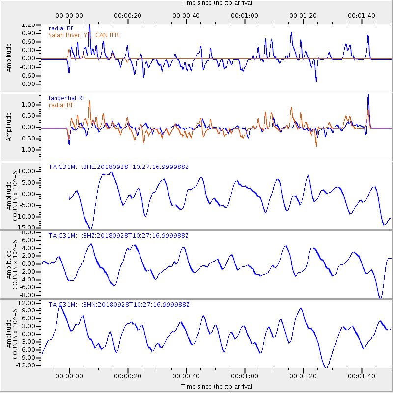
G31M Satah River, YT, CAN - Earthquake Result Viewer
*The percent match for this event was below the threshold and hence no stack was calculated.
| Earthquake location: |
Minahassa Peninsula, Sulawesi |
| Earthquake latitude/longitude: |
0.0/119.8 |
| Earthquake time(UTC): |
2018/09/28 (271) 10:14:20 GMT |
| Earthquake Depth: |
10 km |
| Earthquake Magnitude: |
5.8 mb |
| Earthquake Catalog/Contributor: |
NEIC PDE/us |
|
| Network: |
TA USArray Transportable Network (new EarthScope stations) |
| Station: |
G31M Satah River, YT, CAN |
| Lat/Lon: |
66.92 N/134.27 W |
| Elevation: |
61 m |
|
| Distance: |
96.2 deg |
| Az: |
22.41 deg |
| Baz: |
284.739 deg |
| Ray Param: |
$rayparam |
*The percent match for this event was below the threshold and hence was not used in the summary stack. |
|
| Radial Match: |
65.61236 % |
| Radial Bump: |
400 |
| Transverse Match: |
61.183342 % |
| Transverse Bump: |
400 |
| SOD ConfigId: |
13570011 |
| Insert Time: |
2019-05-01 08:56:42.058 +0000 |
| GWidth: |
2.5 |
| Max Bumps: |
400 |
| Tol: |
0.001 |
|
Signal To Noise
| Channel | StoN | STA | LTA |
| TA:G31M: :BHZ:20180928T10:27:16.999988Z | 2.3549721 | 3.1583845E-6 | 1.3411558E-6 |
| TA:G31M: :BHN:20180928T10:27:16.999988Z | 1.4265338 | 5.7439906E-6 | 4.0265363E-6 |
| TA:G31M: :BHE:20180928T10:27:16.999988Z | 0.7026865 | 4.7815474E-6 | 6.804667E-6 |
| Arrivals |
| Ps | |
| PpPs | |
| PsPs/PpSs | |


