You are here: Home > Network List > TA - USArray Transportable Network (new EarthScope stations) Stations List
> Station H31M Peel River, Yukon, CAN > Earthquake Result Viewer
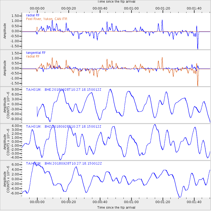
H31M Peel River, Yukon, CAN - Earthquake Result Viewer
*The percent match for this event was below the threshold and hence no stack was calculated.
| Earthquake location: |
Minahassa Peninsula, Sulawesi |
| Earthquake latitude/longitude: |
0.0/119.8 |
| Earthquake time(UTC): |
2018/09/28 (271) 10:14:20 GMT |
| Earthquake Depth: |
10 km |
| Earthquake Magnitude: |
5.8 mb |
| Earthquake Catalog/Contributor: |
NEIC PDE/us |
|
| Network: |
TA USArray Transportable Network (new EarthScope stations) |
| Station: |
H31M Peel River, Yukon, CAN |
| Lat/Lon: |
65.81 N/134.34 W |
| Elevation: |
642 m |
|
| Distance: |
96.5 deg |
| Az: |
23.51 deg |
| Baz: |
284.552 deg |
| Ray Param: |
$rayparam |
*The percent match for this event was below the threshold and hence was not used in the summary stack. |
|
| Radial Match: |
67.4998 % |
| Radial Bump: |
282 |
| Transverse Match: |
40.816936 % |
| Transverse Bump: |
277 |
| SOD ConfigId: |
13570011 |
| Insert Time: |
2019-05-01 08:56:44.585 +0000 |
| GWidth: |
2.5 |
| Max Bumps: |
400 |
| Tol: |
0.001 |
|
Signal To Noise
| Channel | StoN | STA | LTA |
| TA:H31M: :BHZ:20180928T10:27:18.150012Z | 1.6115463 | 2.406405E-6 | 1.4932274E-6 |
| TA:H31M: :BHN:20180928T10:27:18.150012Z | 2.0952132 | 6.6321663E-6 | 3.1653901E-6 |
| TA:H31M: :BHE:20180928T10:27:18.150012Z | 1.0346141 | 5.3792883E-6 | 5.1993184E-6 |
| Arrivals |
| Ps | |
| PpPs | |
| PsPs/PpSs | |


