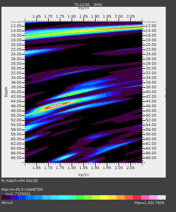
U15A North Rim, AZ, USA - Earthquake Result Viewer

Earthquake location: Fox Islands, Aleutian Islands
Earthquake latitude/longitude: 52.5/-168.0
Earthquake time(UTC): 2007/07/15 (196) 13:08:00 GMT
Earthquake Depth: 10 km
Earthquake Magnitude: 5.8 MB, 5.9 MS, 6.1 MW, 6.0 MW
Earthquake Catalog/Contributor: WHDF/NEIC
Network: TA USArray Transportable Network (new EarthScope stations)
Station: U15A North Rim, AZ, USA
Lat/Lon: 36.43 N/112.29 W
Elevation: 2489 m
Distance: 41.8 deg
Az: 89.78 deg
Baz: 310.68 deg
Ray Param: 0.07355451
Estimated Moho Depth: 45.5 km
Estimated Crust Vp/Vs: 1.73
Assumed Crust Vp: 6.194 km/s
Estimated Crust Vs: 3.575 km/s
Estimated Crust Poisson's Ratio: 0.25
Radial Match: 94.86188 %
Radial Bump: 400
Transverse Match: 88.076164 %
Transverse Bump: 400
SOD ConfigId: 2564
Insert Time: 2010-03-06 16:20:27.702 +0000
GWidth: 2.5
Max Bumps: 400
Tol: 0.001

Signal To Noise

ChannelStoNSTALTA
TA:U15A: :BHN:20070715T13:15:19.700015Z4.99089671.6052873E-73.2164305E-8
TA:U15A: :BHE:20070715T13:15:19.700015Z3.5476781.6237E-74.5767965E-8
TA:U15A: :BHZ:20070715T13:15:19.700015Z7.56126364.1868503E-75.537236E-8
Arrivals
Ps5.7 SECOND
PpPs19 SECOND
PsPs/PpSs25 SECOND