You are here: Home > Network List > TA - USArray Transportable Network (new EarthScope stations) Stations List
> Station U15A North Rim, AZ, USA > Earthquake Result Viewer
U15A North Rim, AZ, USA - Earthquake Result Viewer
| Earthquake location: |
Kamchatka Peninsula, Russia |
| Earthquake latitude/longitude: |
52.1/157.3 |
| Earthquake time(UTC): |
2007/05/30 (150) 20:22:12 GMT |
| Earthquake Depth: |
116 km |
| Earthquake Magnitude: |
6.4 MB, 6.4 MW, 6.4 MW |
| Earthquake Catalog/Contributor: |
WHDF/NEIC |
|
| Network: |
TA USArray Transportable Network (new EarthScope stations) |
| Station: |
U15A North Rim, AZ, USA |
| Lat/Lon: |
36.43 N/112.29 W |
| Elevation: |
2489 m |
|
| Distance: |
62.5 deg |
| Az: |
65.414 deg |
| Baz: |
315.978 deg |
| Ray Param: |
0.05986845 |
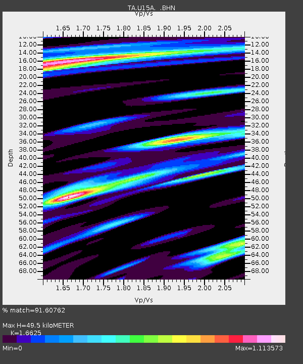
| Estimated Moho Depth: |
49.5 km |
| Estimated Crust Vp/Vs: |
1.66 |
| Assumed Crust Vp: |
6.194 km/s |
| Estimated Crust Vs: |
3.726 km/s |
| Estimated Crust Poisson's Ratio: |
0.22 |
|
| Radial Match: |
91.60762 % |
| Radial Bump: |
400 |
| Transverse Match: |
85.54665 % |
| Transverse Bump: |
400 |
| SOD ConfigId: |
2564 |
| Insert Time: |
2010-03-06 16:20:33.066 +0000 |
| GWidth: |
2.5 |
| Max Bumps: |
400 |
| Tol: |
0.001 |
|

Signal To Noise
| Channel | StoN | STA | LTA |
| TA:U15A: :BHN:20070530T20:31:53.050015Z | 11.137029 | 1.1255801E-6 | 1.0106646E-7 |
| TA:U15A: :BHE:20070530T20:31:53.050015Z | 12.697791 | 1.105245E-6 | 8.70423E-8 |
| TA:U15A: :BHZ:20070530T20:31:53.050015Z | 57.1265 | 4.006989E-6 | 7.014239E-8 |
| Arrivals |
| Ps | 5.5 SECOND |
| PpPs | 20 SECOND |
| PsPs/PpSs | 26 SECOND |


