You are here: Home > Network List > TA - USArray Transportable Network (new EarthScope stations) Stations List
> Station U15A North Rim, AZ, USA > Earthquake Result Viewer
U15A North Rim, AZ, USA - Earthquake Result Viewer
| Earthquake location: |
Sea Of Okhotsk |
| Earthquake latitude/longitude: |
54.2/154.3 |
| Earthquake time(UTC): |
2008/11/24 (329) 09:02:58 GMT |
| Earthquake Depth: |
492 km |
| Earthquake Magnitude: |
6.5 MB, 7.3 MW, 7.3 MW |
| Earthquake Catalog/Contributor: |
WHDF/NEIC |
|
| Network: |
TA USArray Transportable Network (new EarthScope stations) |
| Station: |
U15A North Rim, AZ, USA |
| Lat/Lon: |
36.43 N/112.29 W |
| Elevation: |
2489 m |
|
| Distance: |
63.2 deg |
| Az: |
64.391 deg |
| Baz: |
318.937 deg |
| Ray Param: |
0.057933036 |
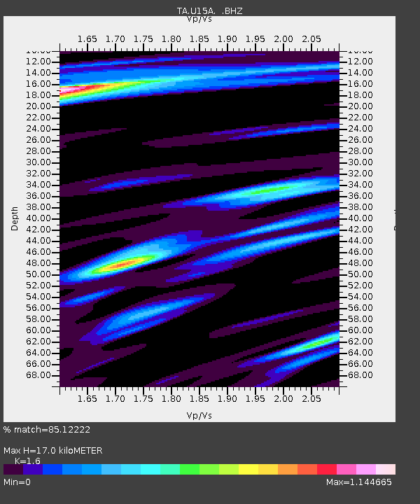
| Estimated Moho Depth: |
17.0 km |
| Estimated Crust Vp/Vs: |
1.60 |
| Assumed Crust Vp: |
6.194 km/s |
| Estimated Crust Vs: |
3.871 km/s |
| Estimated Crust Poisson's Ratio: |
0.18 |
|
| Radial Match: |
85.12222 % |
| Radial Bump: |
342 |
| Transverse Match: |
69.082405 % |
| Transverse Bump: |
400 |
| SOD ConfigId: |
2658 |
| Insert Time: |
2010-03-06 16:20:38.087 +0000 |
| GWidth: |
2.5 |
| Max Bumps: |
400 |
| Tol: |
0.001 |
|

Signal To Noise
| Channel | StoN | STA | LTA |
| TA:U15A: :BHZ:20081124T09:12:07.350027Z | 16.118612 | 3.517504E-6 | 2.1822623E-7 |
| TA:U15A: :BHN:20081124T09:12:07.350027Z | 4.476027 | 1.0646994E-6 | 2.3786708E-7 |
| TA:U15A: :BHE:20081124T09:12:07.350027Z | 3.3078096 | 7.496914E-7 | 2.2664285E-7 |
| Arrivals |
| Ps | 1.7 SECOND |
| PpPs | 6.8 SECOND |
| PsPs/PpSs | 8.6 SECOND |


