You are here: Home > Network List > TA - USArray Transportable Network (new EarthScope stations) Stations List
> Station F21K Alatna River, AK, USA > Earthquake Result Viewer
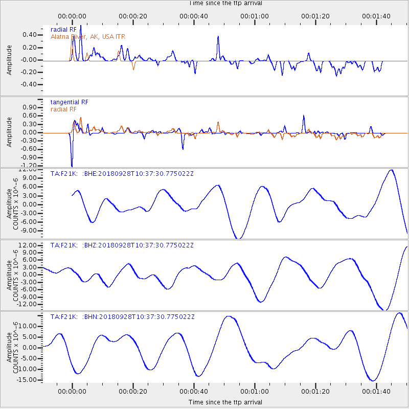
F21K Alatna River, AK, USA - Earthquake Result Viewer
*The percent match for this event was below the threshold and hence no stack was calculated.
| Earthquake location: |
Sulawesi, Indonesia |
| Earthquake latitude/longitude: |
-1.1/120.0 |
| Earthquake time(UTC): |
2018/09/28 (271) 10:25:04 GMT |
| Earthquake Depth: |
10 km |
| Earthquake Magnitude: |
5.8 mb |
| Earthquake Catalog/Contributor: |
NEIC PDE/us |
|
| Network: |
TA USArray Transportable Network (new EarthScope stations) |
| Station: |
F21K Alatna River, AK, USA |
| Lat/Lon: |
67.22 N/153.48 W |
| Elevation: |
597 m |
|
| Distance: |
89.6 deg |
| Az: |
22.872 deg |
| Baz: |
266.417 deg |
| Ray Param: |
$rayparam |
*The percent match for this event was below the threshold and hence was not used in the summary stack. |
|
| Radial Match: |
49.724926 % |
| Radial Bump: |
390 |
| Transverse Match: |
44.717033 % |
| Transverse Bump: |
286 |
| SOD ConfigId: |
13570011 |
| Insert Time: |
2019-05-01 09:03:50.925 +0000 |
| GWidth: |
2.5 |
| Max Bumps: |
400 |
| Tol: |
0.001 |
|
Signal To Noise
| Channel | StoN | STA | LTA |
| TA:F21K: :BHZ:20180928T10:37:30.775022Z | 0.49937162 | 2.1195995E-6 | 4.244533E-6 |
| TA:F21K: :BHN:20180928T10:37:30.775022Z | 3.7635496 | 9.91379E-6 | 2.6341595E-6 |
| TA:F21K: :BHE:20180928T10:37:30.775022Z | 1.6200457 | 4.323313E-6 | 2.6686366E-6 |
| Arrivals |
| Ps | |
| PpPs | |
| PsPs/PpSs | |


