You are here: Home > Network List > TA - USArray Transportable Network (new EarthScope stations) Stations List
> Station O17K Koliganek, Bristol Bay, AK, USA > Earthquake Result Viewer
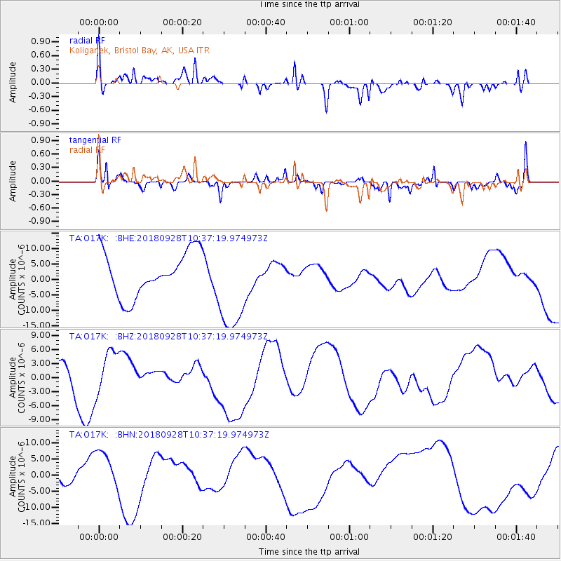
O17K Koliganek, Bristol Bay, AK, USA - Earthquake Result Viewer
*The percent match for this event was below the threshold and hence no stack was calculated.
| Earthquake location: |
Sulawesi, Indonesia |
| Earthquake latitude/longitude: |
-1.1/120.0 |
| Earthquake time(UTC): |
2018/09/28 (271) 10:25:04 GMT |
| Earthquake Depth: |
10 km |
| Earthquake Magnitude: |
5.8 mb |
| Earthquake Catalog/Contributor: |
NEIC PDE/us |
|
| Network: |
TA USArray Transportable Network (new EarthScope stations) |
| Station: |
O17K Koliganek, Bristol Bay, AK, USA |
| Lat/Lon: |
59.77 N/157.09 W |
| Elevation: |
156 m |
|
| Distance: |
87.3 deg |
| Az: |
30.176 deg |
| Baz: |
263.375 deg |
| Ray Param: |
$rayparam |
*The percent match for this event was below the threshold and hence was not used in the summary stack. |
|
| Radial Match: |
65.63824 % |
| Radial Bump: |
400 |
| Transverse Match: |
81.68491 % |
| Transverse Bump: |
400 |
| SOD ConfigId: |
13570011 |
| Insert Time: |
2019-05-01 09:04:08.333 +0000 |
| GWidth: |
2.5 |
| Max Bumps: |
400 |
| Tol: |
0.001 |
|
Signal To Noise
| Channel | StoN | STA | LTA |
| TA:O17K: :BHZ:20180928T10:37:19.974973Z | 0.96574587 | 4.9030023E-6 | 5.0769077E-6 |
| TA:O17K: :BHN:20180928T10:37:19.974973Z | 1.9209068 | 6.1497826E-6 | 3.2014998E-6 |
| TA:O17K: :BHE:20180928T10:37:19.974973Z | 2.1703584 | 1.538067E-5 | 7.0866963E-6 |
| Arrivals |
| Ps | |
| PpPs | |
| PsPs/PpSs | |


