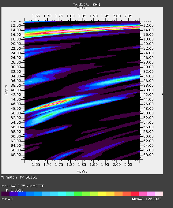
U15A North Rim, AZ, USA - Earthquake Result Viewer

Earthquake location: Andreanof Islands, Aleutian Is.
Earthquake latitude/longitude: 51.9/-177.5
Earthquake time(UTC): 2008/05/02 (123) 01:33:37 GMT
Earthquake Depth: 14 km
Earthquake Magnitude: 6.3 MB, 6.8 MS, 6.6 MW, 6.6 MW
Earthquake Catalog/Contributor: WHDF/NEIC
Network: TA USArray Transportable Network (new EarthScope stations)
Station: U15A North Rim, AZ, USA
Lat/Lon: 36.43 N/112.29 W
Elevation: 2489 m
Distance: 47.7 deg
Az: 82.103 deg
Baz: 310.397 deg
Ray Param: 0.0698275
Estimated Moho Depth: 13.75 km
Estimated Crust Vp/Vs: 1.85
Assumed Crust Vp: 6.194 km/s
Estimated Crust Vs: 3.344 km/s
Estimated Crust Poisson's Ratio: 0.29
Radial Match: 94.58153 %
Radial Bump: 310
Transverse Match: 80.83939 %
Transverse Bump: 400
SOD ConfigId: 2504
Insert Time: 2010-03-06 16:20:58.390 +0000
GWidth: 2.5
Max Bumps: 400
Tol: 0.001

Signal To Noise

ChannelStoNSTALTA
TA:U15A: :BHN:20080502T01:41:42.17399Z7.84161.7697827E-62.2569152E-7
TA:U15A: :BHE:20080502T01:41:42.17399Z1.48395253.809808E-72.567338E-7
TA:U15A: :BHZ:20080502T01:41:42.17399Z3.98382767.736862E-71.9420675E-7
Arrivals
Ps2.0 SECOND
PpPs6.0 SECOND
PsPs/PpSs8.0 SECOND