You are here: Home > Network List > TA - USArray Transportable Network (new EarthScope stations) Stations List
> Station I23K Minto, Yukon-Koyukuk, AK, USA > Earthquake Result Viewer
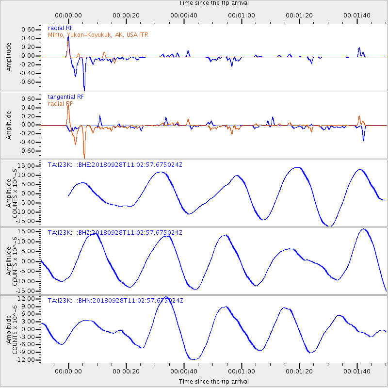
I23K Minto, Yukon-Koyukuk, AK, USA - Earthquake Result Viewer
*The percent match for this event was below the threshold and hence no stack was calculated.
| Earthquake location: |
Minahassa Peninsula, Sulawesi |
| Earthquake latitude/longitude: |
-0.8/119.9 |
| Earthquake time(UTC): |
2018/09/28 (271) 10:50:25 GMT |
| Earthquake Depth: |
10 km |
| Earthquake Magnitude: |
5.7 mb |
| Earthquake Catalog/Contributor: |
NEIC PDE/us |
|
| Network: |
TA USArray Transportable Network (new EarthScope stations) |
| Station: |
I23K Minto, Yukon-Koyukuk, AK, USA |
| Lat/Lon: |
65.15 N/149.36 W |
| Elevation: |
149 m |
|
| Distance: |
91.0 deg |
| Az: |
25.001 deg |
| Baz: |
270.311 deg |
| Ray Param: |
$rayparam |
*The percent match for this event was below the threshold and hence was not used in the summary stack. |
|
| Radial Match: |
91.47322 % |
| Radial Bump: |
283 |
| Transverse Match: |
72.1375 % |
| Transverse Bump: |
310 |
| SOD ConfigId: |
13570011 |
| Insert Time: |
2019-05-01 09:06:42.261 +0000 |
| GWidth: |
2.5 |
| Max Bumps: |
400 |
| Tol: |
0.001 |
|
Signal To Noise
| Channel | StoN | STA | LTA |
| TA:I23K: :BHZ:20180928T11:02:57.675024Z | 2.341958 | 5.833078E-6 | 2.490684E-6 |
| TA:I23K: :BHN:20180928T11:02:57.675024Z | 1.2576354 | 2.4986687E-6 | 1.9867991E-6 |
| TA:I23K: :BHE:20180928T11:02:57.675024Z | 2.730172 | 1.2759389E-5 | 4.673475E-6 |
| Arrivals |
| Ps | |
| PpPs | |
| PsPs/PpSs | |


