You are here: Home > Network List > TA - USArray Transportable Network (new EarthScope stations) Stations List
> Station M31M Drury Creek, Yukon, CA > Earthquake Result Viewer
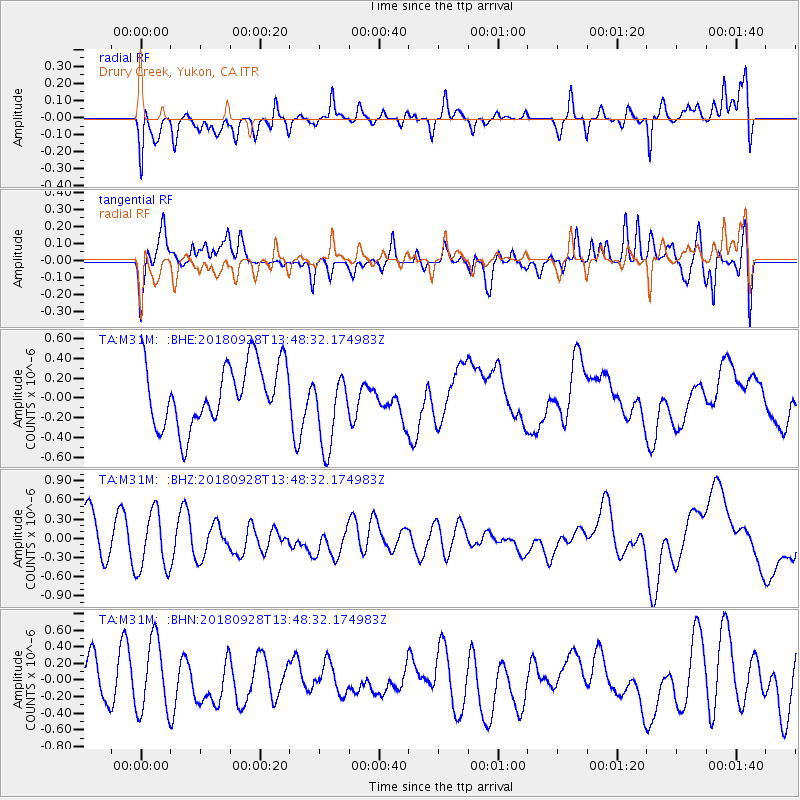
M31M Drury Creek, Yukon, CA - Earthquake Result Viewer
*The percent match for this event was below the threshold and hence no stack was calculated.
| Earthquake location: |
Minahassa Peninsula, Sulawesi |
| Earthquake latitude/longitude: |
0.1/119.7 |
| Earthquake time(UTC): |
2018/09/28 (271) 13:35:30 GMT |
| Earthquake Depth: |
10 km |
| Earthquake Magnitude: |
5.7 Ms_20 |
| Earthquake Catalog/Contributor: |
NEIC PDE/us |
|
| Network: |
TA USArray Transportable Network (new EarthScope stations) |
| Station: |
M31M Drury Creek, Yukon, CA |
| Lat/Lon: |
62.20 N/134.39 W |
| Elevation: |
639 m |
|
| Distance: |
97.3 deg |
| Az: |
27.035 deg |
| Baz: |
284.174 deg |
| Ray Param: |
$rayparam |
*The percent match for this event was below the threshold and hence was not used in the summary stack. |
|
| Radial Match: |
62.541447 % |
| Radial Bump: |
400 |
| Transverse Match: |
58.11974 % |
| Transverse Bump: |
400 |
| SOD ConfigId: |
13570011 |
| Insert Time: |
2019-05-01 09:10:08.916 +0000 |
| GWidth: |
2.5 |
| Max Bumps: |
400 |
| Tol: |
0.001 |
|
Signal To Noise
| Channel | StoN | STA | LTA |
| TA:M31M: :BHZ:20180928T13:48:32.174983Z | 1.4182289 | 4.7419311E-7 | 3.3435586E-7 |
| TA:M31M: :BHN:20180928T13:48:32.174983Z | 1.6016219 | 4.5142588E-7 | 2.8185548E-7 |
| TA:M31M: :BHE:20180928T13:48:32.174983Z | 1.2322313 | 3.8486078E-7 | 3.1232838E-7 |
| Arrivals |
| Ps | |
| PpPs | |
| PsPs/PpSs | |


