You are here: Home > Network List > AK - Alaska Regional Network Stations List
> Station SAMH Samovar Hills, AK, USA > Earthquake Result Viewer
SAMH Samovar Hills, AK, USA - Earthquake Result Viewer
| Earthquake location: |
Fiji Islands Region |
| Earthquake latitude/longitude: |
-18.4/-178.1 |
| Earthquake time(UTC): |
2018/09/30 (273) 10:52:23 GMT |
| Earthquake Depth: |
551 km |
| Earthquake Magnitude: |
6.6 mww |
| Earthquake Catalog/Contributor: |
NEIC PDE/us |
|
| Network: |
AK Alaska Regional Network |
| Station: |
SAMH Samovar Hills, AK, USA |
| Lat/Lon: |
60.13 N/140.78 W |
| Elevation: |
1140 m |
|
| Distance: |
83.9 deg |
| Az: |
17.768 deg |
| Baz: |
215.377 deg |
| Ray Param: |
0.044286035 |
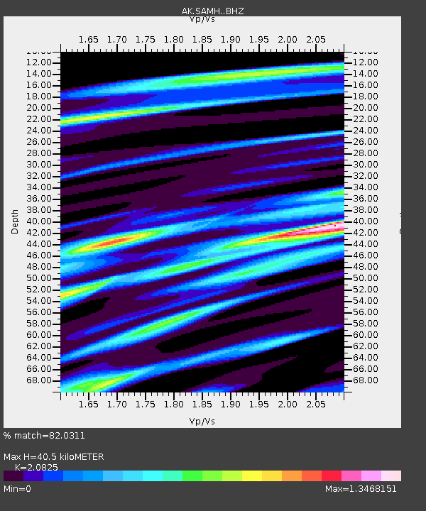
| Estimated Moho Depth: |
40.5 km |
| Estimated Crust Vp/Vs: |
2.08 |
| Assumed Crust Vp: |
6.566 km/s |
| Estimated Crust Vs: |
3.153 km/s |
| Estimated Crust Poisson's Ratio: |
0.35 |
|
| Radial Match: |
82.0311 % |
| Radial Bump: |
400 |
| Transverse Match: |
69.97879 % |
| Transverse Bump: |
400 |
| SOD ConfigId: |
13570011 |
| Insert Time: |
2019-05-01 09:12:21.151 +0000 |
| GWidth: |
2.5 |
| Max Bumps: |
400 |
| Tol: |
0.001 |
|

Signal To Noise
| Channel | StoN | STA | LTA |
| AK:SAMH: :BHZ:20180930T11:03:23.647988Z | 20.596876 | 5.05397E-6 | 2.453756E-7 |
| AK:SAMH: :BHN:20180930T11:03:23.647988Z | 7.452196 | 2.1048531E-6 | 2.8244736E-7 |
| AK:SAMH: :BHE:20180930T11:03:23.647988Z | 3.1006238 | 1.1608125E-6 | 3.7438028E-7 |
| Arrivals |
| Ps | 6.8 SECOND |
| PpPs | 19 SECOND |
| PsPs/PpSs | 25 SECOND |


