You are here: Home > Network List > AU - Australian Seismological Centre Stations List
> Station WB2 Warramunga Array, Australia > Earthquake Result Viewer
WB2 Warramunga Array, Australia - Earthquake Result Viewer
| Earthquake location: |
Fiji Islands Region |
| Earthquake latitude/longitude: |
-18.4/-178.1 |
| Earthquake time(UTC): |
2018/09/30 (273) 10:52:23 GMT |
| Earthquake Depth: |
551 km |
| Earthquake Magnitude: |
6.6 mww |
| Earthquake Catalog/Contributor: |
NEIC PDE/us |
|
| Network: |
AU Australian Seismological Centre |
| Station: |
WB2 Warramunga Array, Australia |
| Lat/Lon: |
19.94 S/134.35 E |
| Elevation: |
388 m |
|
| Distance: |
44.8 deg |
| Az: |
259.946 deg |
| Baz: |
96.304 deg |
| Ray Param: |
0.06898683 |
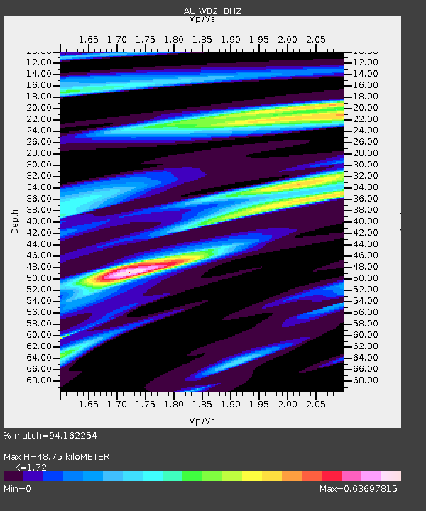
| Estimated Moho Depth: |
48.75 km |
| Estimated Crust Vp/Vs: |
1.72 |
| Assumed Crust Vp: |
6.642 km/s |
| Estimated Crust Vs: |
3.862 km/s |
| Estimated Crust Poisson's Ratio: |
0.24 |
|
| Radial Match: |
94.162254 % |
| Radial Bump: |
202 |
| Transverse Match: |
81.096924 % |
| Transverse Bump: |
400 |
| SOD ConfigId: |
13570011 |
| Insert Time: |
2019-05-01 09:13:00.256 +0000 |
| GWidth: |
2.5 |
| Max Bumps: |
400 |
| Tol: |
0.001 |
|

Signal To Noise
| Channel | StoN | STA | LTA |
| AU:WB2: :BHZ:20180930T10:59:18.150002Z | 36.228325 | 1.2723232E-5 | 3.5119572E-7 |
| AU:WB2: :BHN:20180930T10:59:18.150002Z | 5.6264567 | 1.3228006E-6 | 2.3510366E-7 |
| AU:WB2: :BHE:20180930T10:59:18.150002Z | 40.22712 | 6.6870007E-6 | 1.6623115E-7 |
| Arrivals |
| Ps | 5.6 SECOND |
| PpPs | 19 SECOND |
| PsPs/PpSs | 24 SECOND |


