You are here: Home > Network List > AV - Alaska Volcano Observatory Stations List
> Station PLBL Mt. Peulik Volcano, Alaska > Earthquake Result Viewer
PLBL Mt. Peulik Volcano, Alaska - Earthquake Result Viewer
*The percent match for this event was below the threshold and hence no stack was calculated.
| Earthquake location: |
Fiji Islands Region |
| Earthquake latitude/longitude: |
-18.4/-178.1 |
| Earthquake time(UTC): |
2018/09/30 (273) 10:52:23 GMT |
| Earthquake Depth: |
551 km |
| Earthquake Magnitude: |
6.6 mww |
| Earthquake Catalog/Contributor: |
NEIC PDE/us |
|
| Network: |
AV Alaska Volcano Observatory |
| Station: |
PLBL Mt. Peulik Volcano, Alaska |
| Lat/Lon: |
57.70 N/156.82 W |
| Elevation: |
461 m |
|
| Distance: |
77.8 deg |
| Az: |
11.496 deg |
| Baz: |
200.639 deg |
| Ray Param: |
$rayparam |
*The percent match for this event was below the threshold and hence was not used in the summary stack. |
|
| Radial Match: |
52.805317 % |
| Radial Bump: |
354 |
| Transverse Match: |
47.626614 % |
| Transverse Bump: |
400 |
| SOD ConfigId: |
13570011 |
| Insert Time: |
2019-05-01 09:13:28.632 +0000 |
| GWidth: |
2.5 |
| Max Bumps: |
400 |
| Tol: |
0.001 |
|
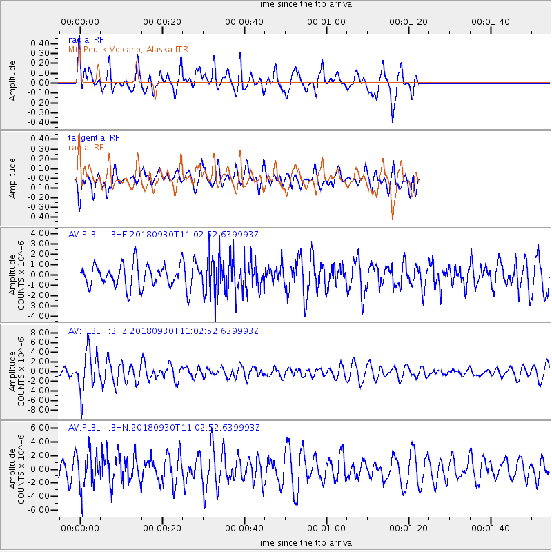
Signal To Noise
| Channel | StoN | STA | LTA |
| AV:PLBL: :BHZ:20180930T11:02:52.639993Z | 5.645785 | 4.2924416E-6 | 7.602914E-7 |
| AV:PLBL: :BHN:20180930T11:02:52.639993Z | 1.8104885 | 2.61087E-6 | 1.4420805E-6 |
| AV:PLBL: :BHE:20180930T11:02:52.639993Z | 1.818839 | 1.9412057E-6 | 1.0672774E-6 |
| Arrivals |
| Ps | |
| PpPs | |
| PsPs/PpSs | |


