You are here: Home > Network List > AV - Alaska Volcano Observatory Stations List
> Station SPBL Spurr Beluga Lake, Mount Spur, Alaska > Earthquake Result Viewer
SPBL Spurr Beluga Lake, Mount Spur, Alaska - Earthquake Result Viewer
| Earthquake location: |
Fiji Islands Region |
| Earthquake latitude/longitude: |
-18.4/-178.1 |
| Earthquake time(UTC): |
2018/09/30 (273) 10:52:23 GMT |
| Earthquake Depth: |
551 km |
| Earthquake Magnitude: |
6.6 mww |
| Earthquake Catalog/Contributor: |
NEIC PDE/us |
|
| Network: |
AV Alaska Volcano Observatory |
| Station: |
SPBL Spurr Beluga Lake, Mount Spur, Alaska |
| Lat/Lon: |
61.38 N/151.89 W |
| Elevation: |
927 m |
|
| Distance: |
82.2 deg |
| Az: |
12.391 deg |
| Baz: |
205.037 deg |
| Ray Param: |
0.04543011 |
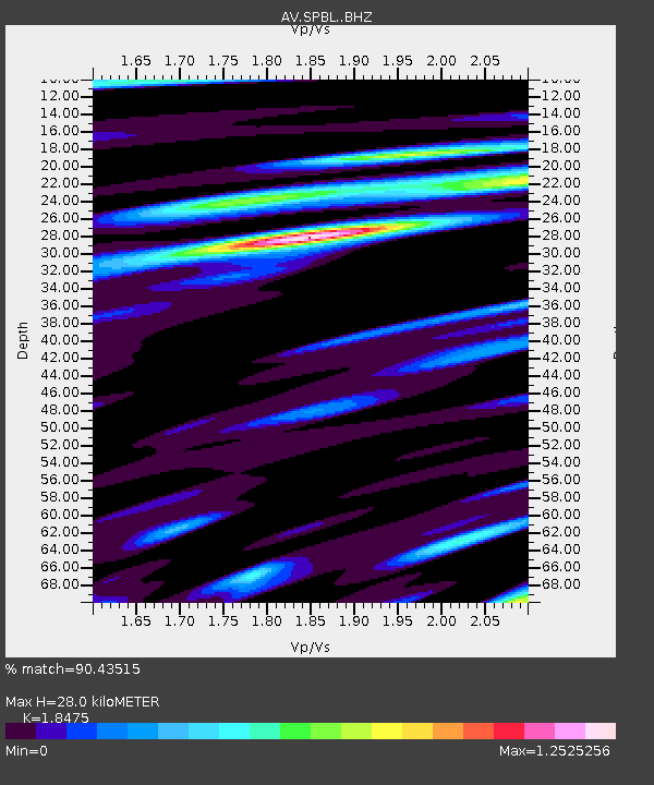
| Estimated Moho Depth: |
28.0 km |
| Estimated Crust Vp/Vs: |
1.85 |
| Assumed Crust Vp: |
6.302 km/s |
| Estimated Crust Vs: |
3.411 km/s |
| Estimated Crust Poisson's Ratio: |
0.29 |
|
| Radial Match: |
90.43515 % |
| Radial Bump: |
400 |
| Transverse Match: |
85.41861 % |
| Transverse Bump: |
400 |
| SOD ConfigId: |
13570011 |
| Insert Time: |
2019-05-01 09:13:40.057 +0000 |
| GWidth: |
2.5 |
| Max Bumps: |
400 |
| Tol: |
0.001 |
|

Signal To Noise
| Channel | StoN | STA | LTA |
| AV:SPBL: :BHZ:20180930T11:03:15.358987Z | 19.51857 | 2.9420612E-6 | 1.5073138E-7 |
| AV:SPBL: :BHN:20180930T11:03:15.358987Z | 10.277722 | 1.126853E-6 | 1.0964034E-7 |
| AV:SPBL: :BHE:20180930T11:03:15.358987Z | 4.2977257 | 5.951909E-7 | 1.3848974E-7 |
| Arrivals |
| Ps | 3.9 SECOND |
| PpPs | 12 SECOND |
| PsPs/PpSs | 16 SECOND |


