You are here: Home > Network List > CB - China National Seismic Network Stations List
> Station HEH Heihe,Heilongjiang Province > Earthquake Result Viewer
HEH Heihe,Heilongjiang Province - Earthquake Result Viewer
| Earthquake location: |
Fiji Islands Region |
| Earthquake latitude/longitude: |
-18.4/-178.1 |
| Earthquake time(UTC): |
2018/09/30 (273) 10:52:23 GMT |
| Earthquake Depth: |
551 km |
| Earthquake Magnitude: |
6.6 mww |
| Earthquake Catalog/Contributor: |
NEIC PDE/us |
|
| Network: |
CB China National Seismic Network |
| Station: |
HEH Heihe,Heilongjiang Province |
| Lat/Lon: |
50.25 N/127.41 E |
| Elevation: |
165 m |
|
| Distance: |
83.5 deg |
| Az: |
328.265 deg |
| Baz: |
128.909 deg |
| Ray Param: |
0.044559944 |
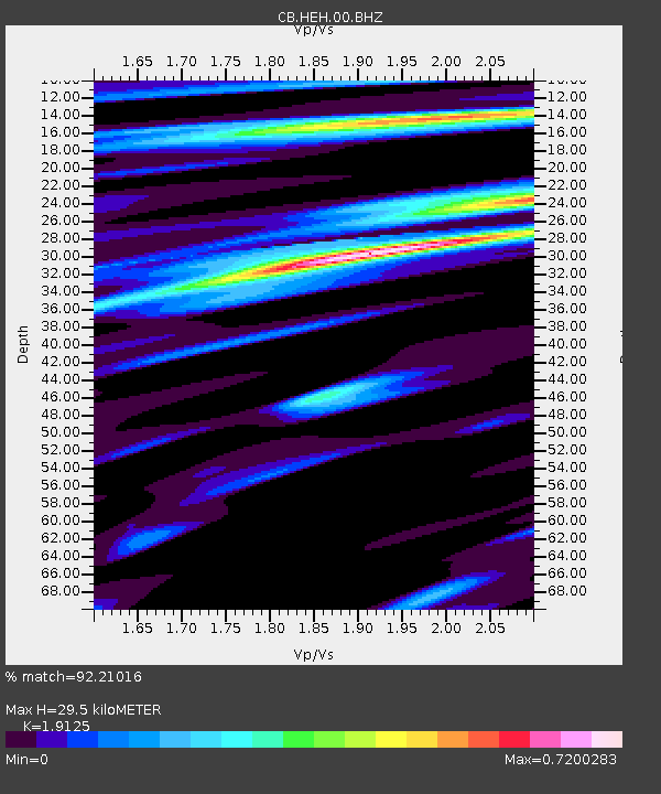
| Estimated Moho Depth: |
29.5 km |
| Estimated Crust Vp/Vs: |
1.91 |
| Assumed Crust Vp: |
6.419 km/s |
| Estimated Crust Vs: |
3.356 km/s |
| Estimated Crust Poisson's Ratio: |
0.31 |
|
| Radial Match: |
92.21016 % |
| Radial Bump: |
215 |
| Transverse Match: |
80.4513 % |
| Transverse Bump: |
218 |
| SOD ConfigId: |
13570011 |
| Insert Time: |
2019-05-01 09:14:39.062 +0000 |
| GWidth: |
2.5 |
| Max Bumps: |
400 |
| Tol: |
0.001 |
|
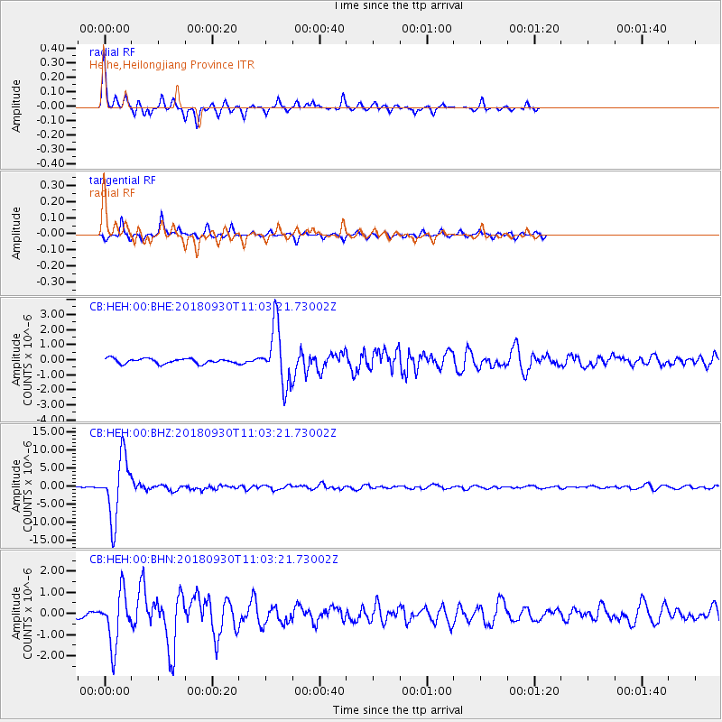
Signal To Noise
| Channel | StoN | STA | LTA |
| CB:HEH:00:BHZ:20180930T11:03:21.73002Z | 41.740936 | 8.581122E-6 | 2.0558049E-7 |
| CB:HEH:00:BHN:20180930T11:03:21.73002Z | 7.288314 | 1.2535974E-6 | 1.7200102E-7 |
| CB:HEH:00:BHE:20180930T11:03:21.73002Z | 11.881644 | 1.977994E-6 | 1.6647476E-7 |
| Arrivals |
| Ps | 4.3 SECOND |
| PpPs | 13 SECOND |
| PsPs/PpSs | 17 SECOND |


