You are here: Home > Network List > CI - Caltech Regional Seismic Network Stations List
> Station DGR Domenigoni Reservoir, California, USA > Earthquake Result Viewer
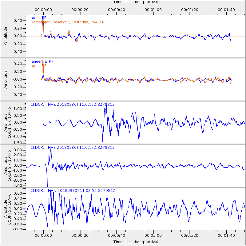
DGR Domenigoni Reservoir, California, USA - Earthquake Result Viewer
*The percent match for this event was below the threshold and hence no stack was calculated.
| Earthquake location: |
Fiji Islands Region |
| Earthquake latitude/longitude: |
-18.4/-178.1 |
| Earthquake time(UTC): |
2018/09/30 (273) 10:52:23 GMT |
| Earthquake Depth: |
551 km |
| Earthquake Magnitude: |
6.6 mww |
| Earthquake Catalog/Contributor: |
NEIC PDE/us |
|
| Network: |
CI Caltech Regional Seismic Network |
| Station: |
DGR Domenigoni Reservoir, California, USA |
| Lat/Lon: |
33.65 N/117.01 W |
| Elevation: |
609 m |
|
| Distance: |
77.9 deg |
| Az: |
48.319 deg |
| Baz: |
238.242 deg |
| Ray Param: |
$rayparam |
*The percent match for this event was below the threshold and hence was not used in the summary stack. |
|
| Radial Match: |
76.14858 % |
| Radial Bump: |
397 |
| Transverse Match: |
50.850365 % |
| Transverse Bump: |
358 |
| SOD ConfigId: |
13570011 |
| Insert Time: |
2019-05-01 09:15:15.848 +0000 |
| GWidth: |
2.5 |
| Max Bumps: |
400 |
| Tol: |
0.001 |
|
Signal To Noise
| Channel | StoN | STA | LTA |
| CI:DGR: :HHZ:20180930T11:02:52.827981Z | 9.414541 | 1.5569344E-6 | 1.653755E-7 |
| CI:DGR: :HHN:20180930T11:02:52.827981Z | 2.5512302 | 3.322549E-7 | 1.3023322E-7 |
| CI:DGR: :HHE:20180930T11:02:52.827981Z | 4.666341 | 6.4772865E-7 | 1.3880869E-7 |
| Arrivals |
| Ps | |
| PpPs | |
| PsPs/PpSs | |


