You are here: Home > Network List > TS - TERRAscope (Southern California Seismic Network) Stations List
> Station BAR Barrett Dam, California, USA > Earthquake Result Viewer
BAR Barrett Dam, California, USA - Earthquake Result Viewer
| Earthquake location: |
Peru-Bolivia Border Region |
| Earthquake latitude/longitude: |
-13.3/-69.4 |
| Earthquake time(UTC): |
1994/01/10 (010) 15:53:49 GMT |
| Earthquake Depth: |
589 km |
| Earthquake Magnitude: |
6.4 MB, 6.4 UNKNOWN, 6.9 MW |
| Earthquake Catalog/Contributor: |
WHDF/NEIC |
|
| Network: |
TS TERRAscope (Southern California Seismic Network) |
| Station: |
BAR Barrett Dam, California, USA |
| Lat/Lon: |
32.68 N/116.67 W |
| Elevation: |
548 m |
|
| Distance: |
64.3 deg |
| Az: |
316.546 deg |
| Baz: |
127.447 deg |
| Ray Param: |
0.056810234 |
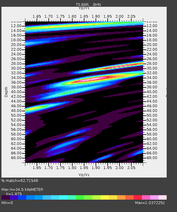
| Estimated Moho Depth: |
34.5 km |
| Estimated Crust Vp/Vs: |
1.88 |
| Assumed Crust Vp: |
6.264 km/s |
| Estimated Crust Vs: |
3.341 km/s |
| Estimated Crust Poisson's Ratio: |
0.30 |
|
| Radial Match: |
92.71549 % |
| Radial Bump: |
400 |
| Transverse Match: |
78.78388 % |
| Transverse Bump: |
400 |
| SOD ConfigId: |
16938 |
| Insert Time: |
2010-02-26 13:57:22.464 +0000 |
| GWidth: |
2.5 |
| Max Bumps: |
400 |
| Tol: |
0.001 |
|
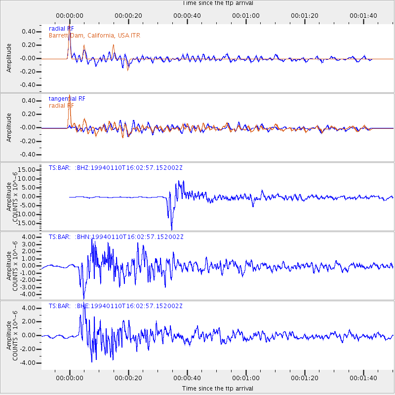
Signal To Noise
| Channel | StoN | STA | LTA |
| TS:BAR: :BHN:19940110T16:02:57.152002Z | 8.6680355 | 1.3255184E-6 | 1.5292026E-7 |
| TS:BAR: :BHE:19940110T16:02:57.152002Z | 7.552642 | 1.408303E-6 | 1.8646494E-7 |
| TS:BAR: :BHZ:19940110T16:02:57.152002Z | 30.908113 | 5.365137E-6 | 1.7358344E-7 |
| Arrivals |
| Ps | 5.0 SECOND |
| PpPs | 15 SECOND |
| PsPs/PpSs | 20 SECOND |


