You are here: Home > Network List > IE - INL Seismic Monitoring Program Stations List
> Station COMI Craters of the Moon, Idaho, USA > Earthquake Result Viewer
COMI Craters of the Moon, Idaho, USA - Earthquake Result Viewer
| Earthquake location: |
Fiji Islands Region |
| Earthquake latitude/longitude: |
-18.4/-178.1 |
| Earthquake time(UTC): |
2018/09/30 (273) 10:52:23 GMT |
| Earthquake Depth: |
551 km |
| Earthquake Magnitude: |
6.6 mww |
| Earthquake Catalog/Contributor: |
NEIC PDE/us |
|
| Network: |
IE INL Seismic Monitoring Program |
| Station: |
COMI Craters of the Moon, Idaho, USA |
| Lat/Lon: |
43.46 N/113.59 W |
| Elevation: |
1890 m |
|
| Distance: |
85.2 deg |
| Az: |
41.26 deg |
| Baz: |
239.33 deg |
| Ray Param: |
0.04333294 |
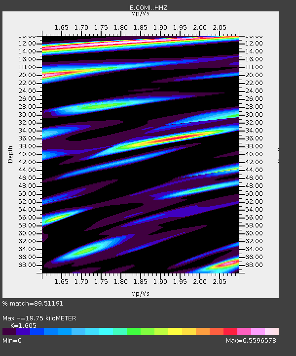
| Estimated Moho Depth: |
19.75 km |
| Estimated Crust Vp/Vs: |
1.61 |
| Assumed Crust Vp: |
6.279 km/s |
| Estimated Crust Vs: |
3.912 km/s |
| Estimated Crust Poisson's Ratio: |
0.18 |
|
| Radial Match: |
89.51191 % |
| Radial Bump: |
400 |
| Transverse Match: |
81.18447 % |
| Transverse Bump: |
400 |
| SOD ConfigId: |
13570011 |
| Insert Time: |
2019-05-01 09:16:43.997 +0000 |
| GWidth: |
2.5 |
| Max Bumps: |
400 |
| Tol: |
0.001 |
|

Signal To Noise
| Channel | StoN | STA | LTA |
| IE:COMI: :HHZ:20180930T11:03:30.327981Z | 21.326834 | 2.3420182E-6 | 1.0981556E-7 |
| IE:COMI: :HHN:20180930T11:03:30.327981Z | 7.253331 | 6.561926E-7 | 9.046776E-8 |
| IE:COMI: :HHE:20180930T11:03:30.327981Z | 4.1188316 | 4.952394E-7 | 1.2023784E-7 |
| Arrivals |
| Ps | 1.9 SECOND |
| PpPs | 8.0 SECOND |
| PsPs/PpSs | 10.0 SECOND |


