You are here: Home > Network List > TS - TERRAscope (Southern California Seismic Network) Stations List
> Station BAR Barrett Dam, California, USA > Earthquake Result Viewer
BAR Barrett Dam, California, USA - Earthquake Result Viewer
| Earthquake location: |
Vanuatu Islands |
| Earthquake latitude/longitude: |
-18.8/169.2 |
| Earthquake time(UTC): |
1994/02/11 (042) 21:17:31 GMT |
| Earthquake Depth: |
204 km |
| Earthquake Magnitude: |
6.3 MB, 7.0 UNKNOWN, 6.8 MW |
| Earthquake Catalog/Contributor: |
WHDF/NEIC |
|
| Network: |
TS TERRAscope (Southern California Seismic Network) |
| Station: |
BAR Barrett Dam, California, USA |
| Lat/Lon: |
32.68 N/116.67 W |
| Elevation: |
548 m |
|
| Distance: |
87.4 deg |
| Az: |
54.311 deg |
| Baz: |
245.819 deg |
| Ray Param: |
0.042890873 |
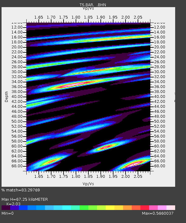
| Estimated Moho Depth: |
67.25 km |
| Estimated Crust Vp/Vs: |
2.03 |
| Assumed Crust Vp: |
6.264 km/s |
| Estimated Crust Vs: |
3.086 km/s |
| Estimated Crust Poisson's Ratio: |
0.34 |
|
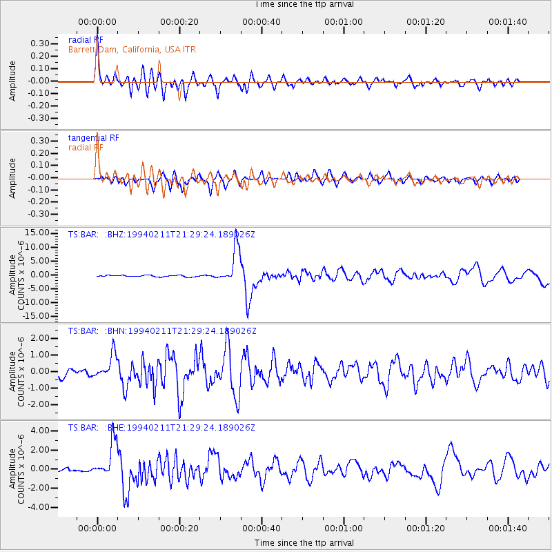
| Radial Match: |
83.29769 % |
| Radial Bump: |
400 |
| Transverse Match: |
84.3473 % |
| Transverse Bump: |
400 |
| SOD ConfigId: |
16938 |
| Insert Time: |
2010-02-26 13:57:24.027 +0000 |
| GWidth: |
2.5 |
| Max Bumps: |
400 |
| Tol: |
0.001 |
|
Signal To Noise
| Channel | StoN | STA | LTA |
| TS:BAR: :BHN:19940211T21:29:24.189026Z | 4.4847198 | 7.713135E-7 | 1.71987E-7 |
| TS:BAR: :BHE:19940211T21:29:24.189026Z | 14.466545 | 2.0487173E-6 | 1.4161759E-7 |
| TS:BAR: :BHZ:19940211T21:29:24.189026Z | 24.455784 | 6.775212E-6 | 2.7703925E-7 |
| Arrivals |
| Ps | 11 SECOND |
| PpPs | 32 SECOND |
| PsPs/PpSs | 43 SECOND |


