You are here: Home > Network List > TA - USArray Transportable Network (new EarthScope stations) Stations List
> Station 833A Chaparral WMA, Artesia Wells, TX, USA > Earthquake Result Viewer
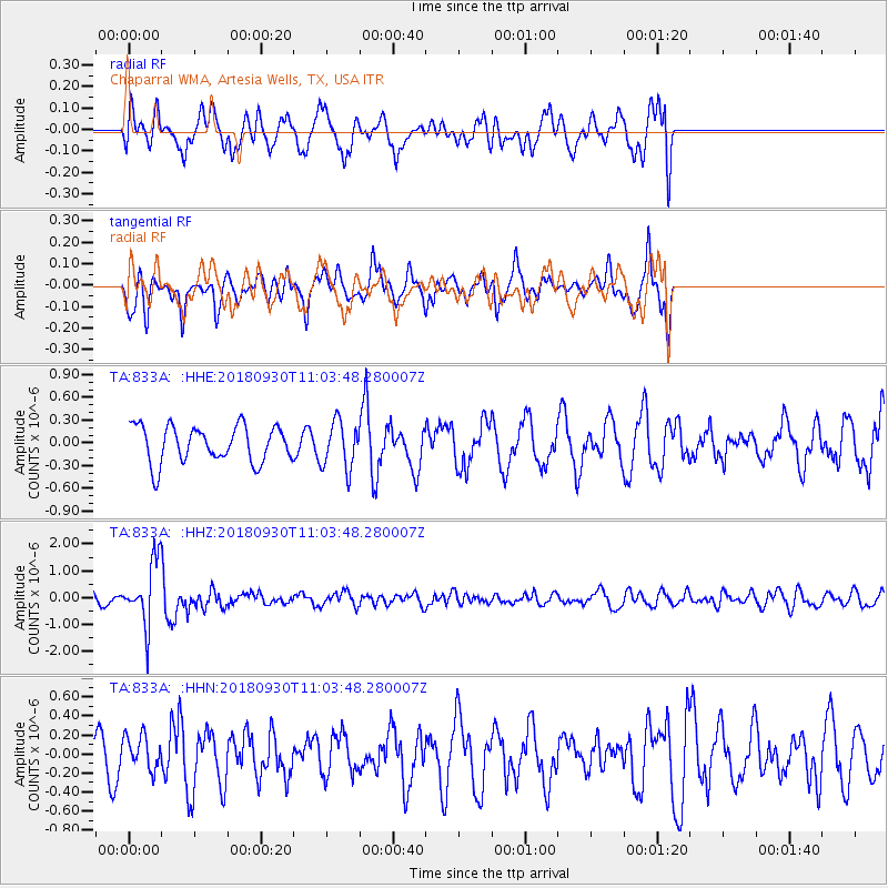
833A Chaparral WMA, Artesia Wells, TX, USA - Earthquake Result Viewer
*The percent match for this event was below the threshold and hence no stack was calculated.
| Earthquake location: |
Fiji Islands Region |
| Earthquake latitude/longitude: |
-18.4/-178.1 |
| Earthquake time(UTC): |
2018/09/30 (273) 10:52:23 GMT |
| Earthquake Depth: |
551 km |
| Earthquake Magnitude: |
6.6 mww |
| Earthquake Catalog/Contributor: |
NEIC PDE/us |
|
| Network: |
TA USArray Transportable Network (new EarthScope stations) |
| Station: |
833A Chaparral WMA, Artesia Wells, TX, USA |
| Lat/Lon: |
28.32 N/99.39 W |
| Elevation: |
171 m |
|
| Distance: |
89.1 deg |
| Az: |
59.841 deg |
| Baz: |
248.65 deg |
| Ray Param: |
$rayparam |
*The percent match for this event was below the threshold and hence was not used in the summary stack. |
|
| Radial Match: |
52.508965 % |
| Radial Bump: |
400 |
| Transverse Match: |
56.9746 % |
| Transverse Bump: |
351 |
| SOD ConfigId: |
13570011 |
| Insert Time: |
2019-05-01 09:19:37.206 +0000 |
| GWidth: |
2.5 |
| Max Bumps: |
400 |
| Tol: |
0.001 |
|
Signal To Noise
| Channel | StoN | STA | LTA |
| TA:833A: :HHZ:20180930T11:03:48.280007Z | 5.676556 | 1.2109798E-6 | 2.1333001E-7 |
| TA:833A: :HHN:20180930T11:03:48.280007Z | 0.5454161 | 1.80815E-7 | 3.315175E-7 |
| TA:833A: :HHE:20180930T11:03:48.280007Z | 1.2820605 | 3.0654027E-7 | 2.390997E-7 |
| Arrivals |
| Ps | |
| PpPs | |
| PsPs/PpSs | |


