You are here: Home > Network List > TA - USArray Transportable Network (new EarthScope stations) Stations List
> Station B18K Kokolik River, AK, USA > Earthquake Result Viewer
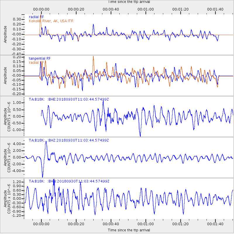
B18K Kokolik River, AK, USA - Earthquake Result Viewer
*The percent match for this event was below the threshold and hence no stack was calculated.
| Earthquake location: |
Fiji Islands Region |
| Earthquake latitude/longitude: |
-18.4/-178.1 |
| Earthquake time(UTC): |
2018/09/30 (273) 10:52:23 GMT |
| Earthquake Depth: |
551 km |
| Earthquake Magnitude: |
6.6 mww |
| Earthquake Catalog/Contributor: |
NEIC PDE/us |
|
| Network: |
TA USArray Transportable Network (new EarthScope stations) |
| Station: |
B18K Kokolik River, AK, USA |
| Lat/Lon: |
69.36 N/161.80 W |
| Elevation: |
222 m |
|
| Distance: |
88.3 deg |
| Az: |
5.711 deg |
| Baz: |
195.459 deg |
| Ray Param: |
$rayparam |
*The percent match for this event was below the threshold and hence was not used in the summary stack. |
|
| Radial Match: |
61.771492 % |
| Radial Bump: |
400 |
| Transverse Match: |
75.919975 % |
| Transverse Bump: |
400 |
| SOD ConfigId: |
13570011 |
| Insert Time: |
2019-05-01 09:19:40.834 +0000 |
| GWidth: |
2.5 |
| Max Bumps: |
400 |
| Tol: |
0.001 |
|
Signal To Noise
| Channel | StoN | STA | LTA |
| TA:B18K: :BHZ:20180930T11:03:44.57499Z | 4.885034 | 2.7964545E-6 | 5.724534E-7 |
| TA:B18K: :BHN:20180930T11:03:44.57499Z | 0.92401904 | 4.4284016E-7 | 4.7925437E-7 |
| TA:B18K: :BHE:20180930T11:03:44.57499Z | 1.787498 | 4.97936E-7 | 2.785659E-7 |
| Arrivals |
| Ps | |
| PpPs | |
| PsPs/PpSs | |


