You are here: Home > Network List > TA - USArray Transportable Network (new EarthScope stations) Stations List
> Station E20K Nigu River, AK, USA > Earthquake Result Viewer
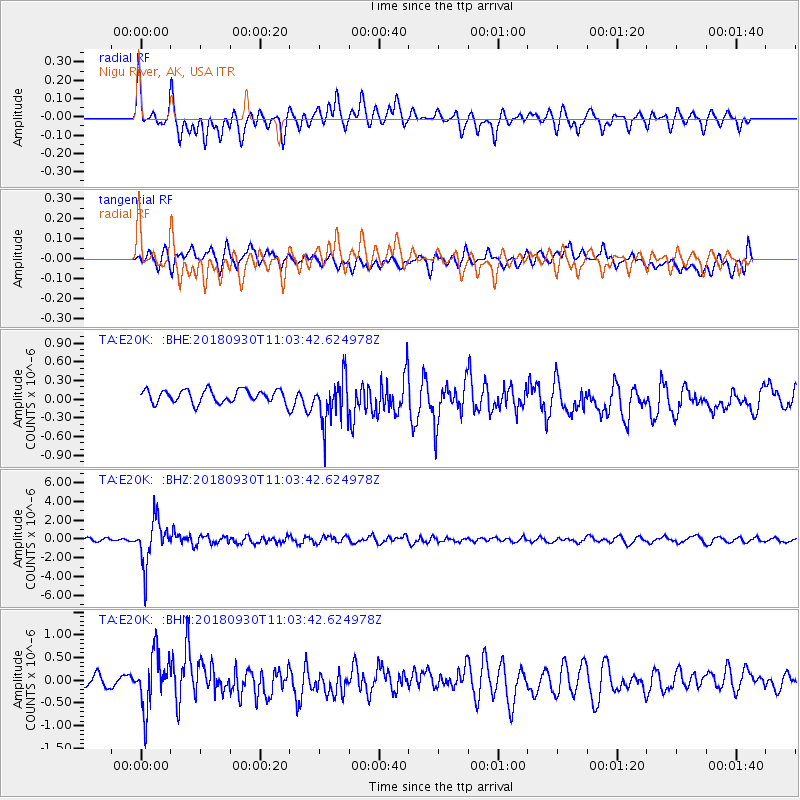
E20K Nigu River, AK, USA - Earthquake Result Viewer
*The percent match for this event was below the threshold and hence no stack was calculated.
| Earthquake location: |
Fiji Islands Region |
| Earthquake latitude/longitude: |
-18.4/-178.1 |
| Earthquake time(UTC): |
2018/09/30 (273) 10:52:23 GMT |
| Earthquake Depth: |
551 km |
| Earthquake Magnitude: |
6.6 mww |
| Earthquake Catalog/Contributor: |
NEIC PDE/us |
|
| Network: |
TA USArray Transportable Network (new EarthScope stations) |
| Station: |
E20K Nigu River, AK, USA |
| Lat/Lon: |
68.26 N/156.19 W |
| Elevation: |
866 m |
|
| Distance: |
87.8 deg |
| Az: |
7.996 deg |
| Baz: |
200.766 deg |
| Ray Param: |
$rayparam |
*The percent match for this event was below the threshold and hence was not used in the summary stack. |
|
| Radial Match: |
75.0716 % |
| Radial Bump: |
400 |
| Transverse Match: |
57.119232 % |
| Transverse Bump: |
400 |
| SOD ConfigId: |
13570011 |
| Insert Time: |
2019-05-01 09:19:58.793 +0000 |
| GWidth: |
2.5 |
| Max Bumps: |
400 |
| Tol: |
0.001 |
|
Signal To Noise
| Channel | StoN | STA | LTA |
| TA:E20K: :BHZ:20180930T11:03:42.624978Z | 14.644792 | 2.3654545E-6 | 1.615219E-7 |
| TA:E20K: :BHN:20180930T11:03:42.624978Z | 4.188935 | 6.121721E-7 | 1.4614028E-7 |
| TA:E20K: :BHE:20180930T11:03:42.624978Z | 3.4452784 | 3.7055366E-7 | 1.0755405E-7 |
| Arrivals |
| Ps | |
| PpPs | |
| PsPs/PpSs | |


