You are here: Home > Network List > TA - USArray Transportable Network (new EarthScope stations) Stations List
> Station G17K Kiwalik Mountain, AK, USA > Earthquake Result Viewer
G17K Kiwalik Mountain, AK, USA - Earthquake Result Viewer
| Earthquake location: |
Fiji Islands Region |
| Earthquake latitude/longitude: |
-18.4/-178.1 |
| Earthquake time(UTC): |
2018/09/30 (273) 10:52:23 GMT |
| Earthquake Depth: |
551 km |
| Earthquake Magnitude: |
6.6 mww |
| Earthquake Catalog/Contributor: |
NEIC PDE/us |
|
| Network: |
TA USArray Transportable Network (new EarthScope stations) |
| Station: |
G17K Kiwalik Mountain, AK, USA |
| Lat/Lon: |
65.50 N/160.65 W |
| Elevation: |
338 m |
|
| Distance: |
84.7 deg |
| Az: |
7.212 deg |
| Baz: |
196.614 deg |
| Ray Param: |
0.043735713 |
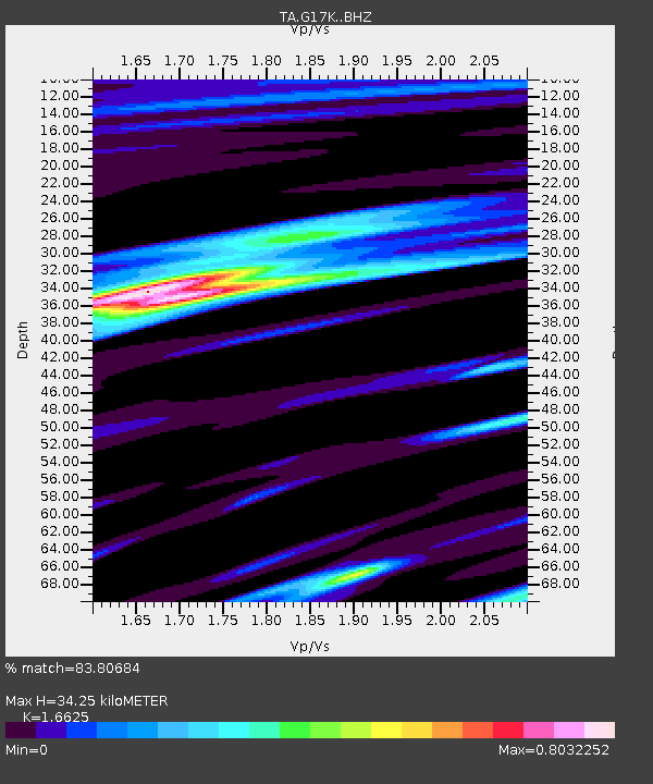
| Estimated Moho Depth: |
34.25 km |
| Estimated Crust Vp/Vs: |
1.66 |
| Assumed Crust Vp: |
6.276 km/s |
| Estimated Crust Vs: |
3.775 km/s |
| Estimated Crust Poisson's Ratio: |
0.22 |
|
| Radial Match: |
83.80684 % |
| Radial Bump: |
312 |
| Transverse Match: |
80.97662 % |
| Transverse Bump: |
384 |
| SOD ConfigId: |
13570011 |
| Insert Time: |
2019-05-01 09:20:16.101 +0000 |
| GWidth: |
2.5 |
| Max Bumps: |
400 |
| Tol: |
0.001 |
|

Signal To Noise
| Channel | StoN | STA | LTA |
| TA:G17K: :BHZ:20180930T11:03:27.550027Z | 16.518593 | 3.3274691E-6 | 2.014378E-7 |
| TA:G17K: :BHN:20180930T11:03:27.550027Z | 5.506725 | 8.138582E-7 | 1.4779351E-7 |
| TA:G17K: :BHE:20180930T11:03:27.550027Z | 3.8586664 | 7.240231E-7 | 1.8763558E-7 |
| Arrivals |
| Ps | 3.7 SECOND |
| PpPs | 14 SECOND |
| PsPs/PpSs | 18 SECOND |


