You are here: Home > Network List > TA - USArray Transportable Network (new EarthScope stations) Stations List
> Station G23K Bananza Creek, AK, USA > Earthquake Result Viewer
G23K Bananza Creek, AK, USA - Earthquake Result Viewer
| Earthquake location: |
Fiji Islands Region |
| Earthquake latitude/longitude: |
-18.4/-178.1 |
| Earthquake time(UTC): |
2018/09/30 (273) 10:52:23 GMT |
| Earthquake Depth: |
551 km |
| Earthquake Magnitude: |
6.6 mww |
| Earthquake Catalog/Contributor: |
NEIC PDE/us |
|
| Network: |
TA USArray Transportable Network (new EarthScope stations) |
| Station: |
G23K Bananza Creek, AK, USA |
| Lat/Lon: |
66.71 N/150.02 W |
| Elevation: |
746 m |
|
| Distance: |
87.4 deg |
| Az: |
10.795 deg |
| Baz: |
206.573 deg |
| Ray Param: |
0.04182362 |
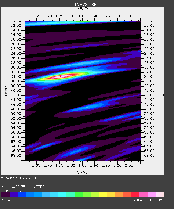
| Estimated Moho Depth: |
33.75 km |
| Estimated Crust Vp/Vs: |
1.75 |
| Assumed Crust Vp: |
6.577 km/s |
| Estimated Crust Vs: |
3.753 km/s |
| Estimated Crust Poisson's Ratio: |
0.26 |
|
| Radial Match: |
87.97886 % |
| Radial Bump: |
300 |
| Transverse Match: |
82.5132 % |
| Transverse Bump: |
397 |
| SOD ConfigId: |
13570011 |
| Insert Time: |
2019-05-01 09:20:22.445 +0000 |
| GWidth: |
2.5 |
| Max Bumps: |
400 |
| Tol: |
0.001 |
|
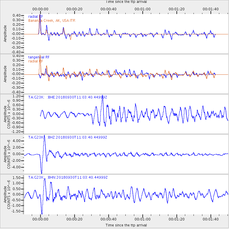
Signal To Noise
| Channel | StoN | STA | LTA |
| TA:G23K: :BHZ:20180930T11:03:40.44999Z | 24.303844 | 2.9337575E-6 | 1.2071166E-7 |
| TA:G23K: :BHN:20180930T11:03:40.44999Z | 5.5312076 | 8.5214106E-7 | 1.5406059E-7 |
| TA:G23K: :BHE:20180930T11:03:40.44999Z | 3.203003 | 4.031787E-7 | 1.2587522E-7 |
| Arrivals |
| Ps | 3.9 SECOND |
| PpPs | 14 SECOND |
| PsPs/PpSs | 18 SECOND |


