You are here: Home > Network List > TA - USArray Transportable Network (new EarthScope stations) Stations List
> Station G26K Porcupine River, AK, USA > Earthquake Result Viewer
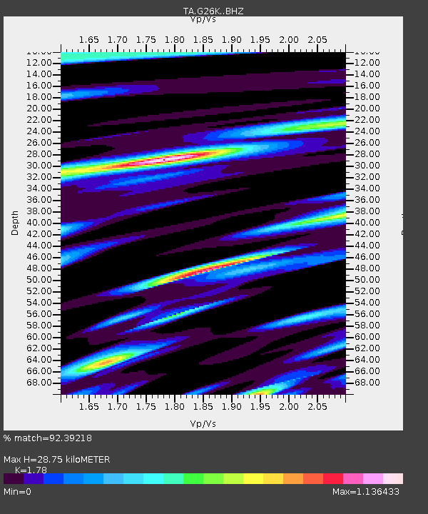
G26K Porcupine River, AK, USA - Earthquake Result Viewer
| Earthquake location: |
Fiji Islands Region |
| Earthquake latitude/longitude: |
-18.4/-178.1 |
| Earthquake time(UTC): |
2018/09/30 (273) 10:52:23 GMT |
| Earthquake Depth: |
551 km |
| Earthquake Magnitude: |
6.6 mww |
| Earthquake Catalog/Contributor: |
NEIC PDE/us |
|
| Network: |
TA USArray Transportable Network (new EarthScope stations) |
| Station: |
G26K Porcupine River, AK, USA |
| Lat/Lon: |
66.95 N/143.78 W |
| Elevation: |
180 m |
|
| Distance: |
88.8 deg |
| Az: |
12.827 deg |
| Baz: |
212.372 deg |
| Ray Param: |
0.04164138 |
| Estimated Moho Depth: |
28.75 km |
| Estimated Crust Vp/Vs: |
1.78 |
| Assumed Crust Vp: |
6.577 km/s |
| Estimated Crust Vs: |
3.695 km/s |
| Estimated Crust Poisson's Ratio: |
0.27 |
|
| Radial Match: |
92.39218 % |
| Radial Bump: |
400 |
| Transverse Match: |
84.24486 % |
| Transverse Bump: |
400 |
| SOD ConfigId: |
13570011 |
| Insert Time: |
2019-05-01 09:20:24.012 +0000 |
| GWidth: |
2.5 |
| Max Bumps: |
400 |
| Tol: |
0.001 |
|

Signal To Noise
| Channel | StoN | STA | LTA |
| TA:G26K: :BHZ:20180930T11:03:47.025002Z | 21.413229 | 2.7497483E-6 | 1.2841353E-7 |
| TA:G26K: :BHN:20180930T11:03:47.025002Z | 9.563193 | 1.4825438E-6 | 1.55026E-7 |
| TA:G26K: :BHE:20180930T11:03:47.025002Z | 3.2777345 | 6.734439E-7 | 2.0546017E-7 |
| Arrivals |
| Ps | 3.5 SECOND |
| PpPs | 12 SECOND |
| PsPs/PpSs | 15 SECOND |


