You are here: Home > Network List > TA - USArray Transportable Network (new EarthScope stations) Stations List
> Station G31M Satah River, YT, CAN > Earthquake Result Viewer
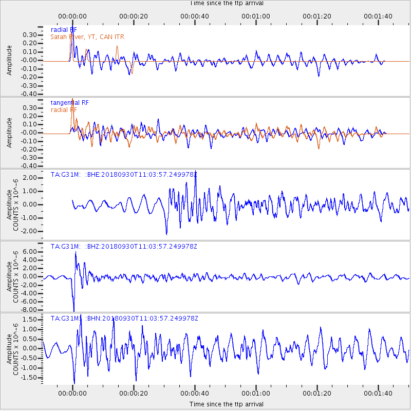
G31M Satah River, YT, CAN - Earthquake Result Viewer
*The percent match for this event was below the threshold and hence no stack was calculated.
| Earthquake location: |
Fiji Islands Region |
| Earthquake latitude/longitude: |
-18.4/-178.1 |
| Earthquake time(UTC): |
2018/09/30 (273) 10:52:23 GMT |
| Earthquake Depth: |
551 km |
| Earthquake Magnitude: |
6.6 mww |
| Earthquake Catalog/Contributor: |
NEIC PDE/us |
|
| Network: |
TA USArray Transportable Network (new EarthScope stations) |
| Station: |
G31M Satah River, YT, CAN |
| Lat/Lon: |
66.92 N/134.27 W |
| Elevation: |
61 m |
|
| Distance: |
91.0 deg |
| Az: |
15.843 deg |
| Baz: |
221.124 deg |
| Ray Param: |
$rayparam |
*The percent match for this event was below the threshold and hence was not used in the summary stack. |
|
| Radial Match: |
61.68566 % |
| Radial Bump: |
400 |
| Transverse Match: |
57.77548 % |
| Transverse Bump: |
400 |
| SOD ConfigId: |
13570011 |
| Insert Time: |
2019-05-01 09:20:25.835 +0000 |
| GWidth: |
2.5 |
| Max Bumps: |
400 |
| Tol: |
0.001 |
|
Signal To Noise
| Channel | StoN | STA | LTA |
| TA:G31M: :BHZ:20180930T11:03:57.249978Z | 15.100169 | 3.1621246E-6 | 2.0940988E-7 |
| TA:G31M: :BHN:20180930T11:03:57.249978Z | 2.4284306 | 8.00037E-7 | 3.294461E-7 |
| TA:G31M: :BHE:20180930T11:03:57.249978Z | 2.807931 | 8.7241926E-7 | 3.1069828E-7 |
| Arrivals |
| Ps | |
| PpPs | |
| PsPs/PpSs | |


