You are here: Home > Network List > TA - USArray Transportable Network (new EarthScope stations) Stations List
> Station H23K Yukon River, AK, USA > Earthquake Result Viewer
H23K Yukon River, AK, USA - Earthquake Result Viewer
| Earthquake location: |
Fiji Islands Region |
| Earthquake latitude/longitude: |
-18.4/-178.1 |
| Earthquake time(UTC): |
2018/09/30 (273) 10:52:23 GMT |
| Earthquake Depth: |
551 km |
| Earthquake Magnitude: |
6.6 mww |
| Earthquake Catalog/Contributor: |
NEIC PDE/us |
|
| Network: |
TA USArray Transportable Network (new EarthScope stations) |
| Station: |
H23K Yukon River, AK, USA |
| Lat/Lon: |
65.83 N/149.54 W |
| Elevation: |
617 m |
|
| Distance: |
86.7 deg |
| Az: |
11.371 deg |
| Baz: |
207.043 deg |
| Ray Param: |
0.042318568 |
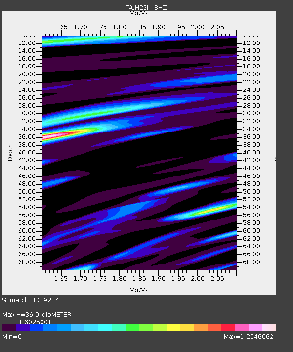
| Estimated Moho Depth: |
36.0 km |
| Estimated Crust Vp/Vs: |
1.60 |
| Assumed Crust Vp: |
6.566 km/s |
| Estimated Crust Vs: |
4.097 km/s |
| Estimated Crust Poisson's Ratio: |
0.18 |
|
| Radial Match: |
83.92141 % |
| Radial Bump: |
290 |
| Transverse Match: |
69.23632 % |
| Transverse Bump: |
317 |
| SOD ConfigId: |
13570011 |
| Insert Time: |
2019-05-01 09:20:30.413 +0000 |
| GWidth: |
2.5 |
| Max Bumps: |
400 |
| Tol: |
0.001 |
|

Signal To Noise
| Channel | StoN | STA | LTA |
| TA:H23K: :BHZ:20180930T11:03:37.150002Z | 16.063778 | 2.1675703E-6 | 1.3493528E-7 |
| TA:H23K: :BHN:20180930T11:03:37.150002Z | 5.2643256 | 7.8734075E-7 | 1.4956156E-7 |
| TA:H23K: :BHE:20180930T11:03:37.150002Z | 2.3390534 | 3.974134E-7 | 1.6990353E-7 |
| Arrivals |
| Ps | 3.4 SECOND |
| PpPs | 14 SECOND |
| PsPs/PpSs | 17 SECOND |


