You are here: Home > Network List > TA - USArray Transportable Network (new EarthScope stations) Stations List
> Station L26K Log Cabin Wilderness Lodge, Tok, AK, USA > Earthquake Result Viewer
L26K Log Cabin Wilderness Lodge, Tok, AK, USA - Earthquake Result Viewer
| Earthquake location: |
Fiji Islands Region |
| Earthquake latitude/longitude: |
-18.4/-178.1 |
| Earthquake time(UTC): |
2018/09/30 (273) 10:52:23 GMT |
| Earthquake Depth: |
551 km |
| Earthquake Magnitude: |
6.6 mww |
| Earthquake Catalog/Contributor: |
NEIC PDE/us |
|
| Network: |
TA USArray Transportable Network (new EarthScope stations) |
| Station: |
L26K Log Cabin Wilderness Lodge, Tok, AK, USA |
| Lat/Lon: |
63.03 N/143.35 W |
| Elevation: |
650 m |
|
| Distance: |
85.6 deg |
| Az: |
15.111 deg |
| Baz: |
212.88 deg |
| Ray Param: |
0.043095507 |
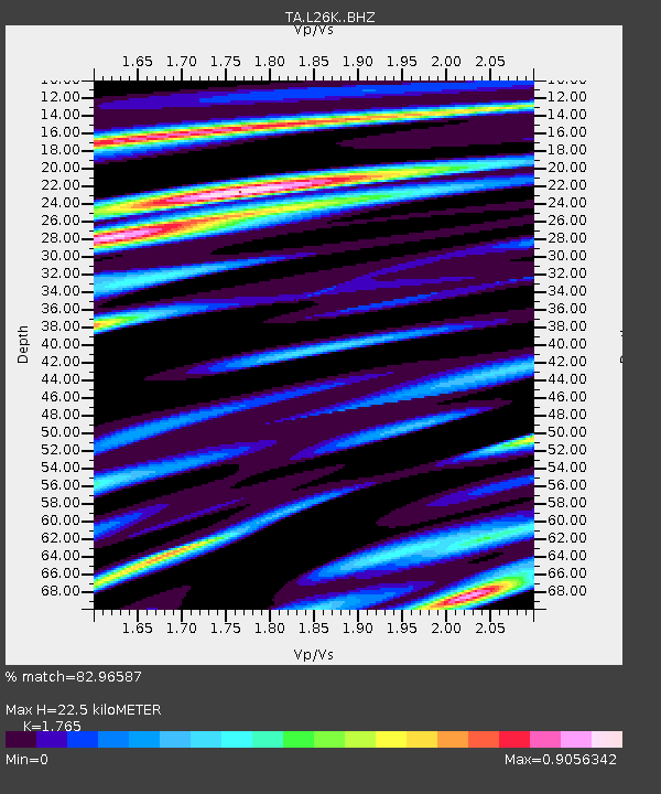
| Estimated Moho Depth: |
22.5 km |
| Estimated Crust Vp/Vs: |
1.76 |
| Assumed Crust Vp: |
6.566 km/s |
| Estimated Crust Vs: |
3.72 km/s |
| Estimated Crust Poisson's Ratio: |
0.26 |
|
| Radial Match: |
82.96587 % |
| Radial Bump: |
400 |
| Transverse Match: |
86.96416 % |
| Transverse Bump: |
400 |
| SOD ConfigId: |
13570011 |
| Insert Time: |
2019-05-01 09:21:00.747 +0000 |
| GWidth: |
2.5 |
| Max Bumps: |
400 |
| Tol: |
0.001 |
|

Signal To Noise
| Channel | StoN | STA | LTA |
| TA:L26K: :BHZ:20180930T11:03:31.975015Z | 24.537008 | 3.405695E-6 | 1.387983E-7 |
| TA:L26K: :BHN:20180930T11:03:31.975015Z | 4.86037 | 8.6660225E-7 | 1.7829964E-7 |
| TA:L26K: :BHE:20180930T11:03:31.975015Z | 4.353242 | 6.0327596E-7 | 1.3858086E-7 |
| Arrivals |
| Ps | 2.7 SECOND |
| PpPs | 9.3 SECOND |
| PsPs/PpSs | 12 SECOND |


