You are here: Home > Network List > TA - USArray Transportable Network (new EarthScope stations) Stations List
> Station M11K Mekoryuk, AK, USA > Earthquake Result Viewer
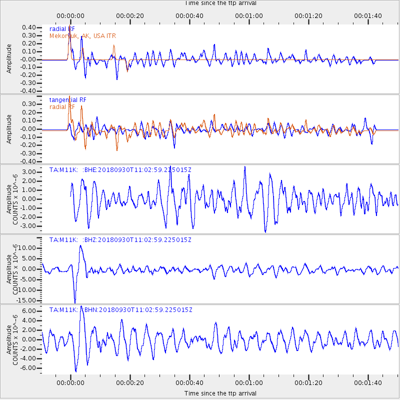
M11K Mekoryuk, AK, USA - Earthquake Result Viewer
*The percent match for this event was below the threshold and hence no stack was calculated.
| Earthquake location: |
Fiji Islands Region |
| Earthquake latitude/longitude: |
-18.4/-178.1 |
| Earthquake time(UTC): |
2018/09/30 (273) 10:52:23 GMT |
| Earthquake Depth: |
551 km |
| Earthquake Magnitude: |
6.6 mww |
| Earthquake Catalog/Contributor: |
NEIC PDE/us |
|
| Network: |
TA USArray Transportable Network (new EarthScope stations) |
| Station: |
M11K Mekoryuk, AK, USA |
| Lat/Lon: |
60.38 N/166.20 W |
| Elevation: |
3.0 m |
|
| Distance: |
79.1 deg |
| Az: |
5.984 deg |
| Baz: |
191.498 deg |
| Ray Param: |
$rayparam |
*The percent match for this event was below the threshold and hence was not used in the summary stack. |
|
| Radial Match: |
66.92352 % |
| Radial Bump: |
400 |
| Transverse Match: |
65.362915 % |
| Transverse Bump: |
400 |
| SOD ConfigId: |
13570011 |
| Insert Time: |
2019-05-01 09:21:02.455 +0000 |
| GWidth: |
2.5 |
| Max Bumps: |
400 |
| Tol: |
0.001 |
|
Signal To Noise
| Channel | StoN | STA | LTA |
| TA:M11K: :BHZ:20180930T11:02:59.225015Z | 5.563755 | 7.1885224E-6 | 1.2920272E-6 |
| TA:M11K: :BHN:20180930T11:02:59.225015Z | 3.0370195 | 4.1103226E-6 | 1.3534066E-6 |
| TA:M11K: :BHE:20180930T11:02:59.225015Z | 1.5711033 | 1.8033692E-6 | 1.1478362E-6 |
| Arrivals |
| Ps | |
| PpPs | |
| PsPs/PpSs | |


