You are here: Home > Network List > TA - USArray Transportable Network (new EarthScope stations) Stations List
> Station U18A Rough Rock, Chinle, AZ, USA > Earthquake Result Viewer
U18A Rough Rock, Chinle, AZ, USA - Earthquake Result Viewer
| Earthquake location: |
Tonga Islands |
| Earthquake latitude/longitude: |
-15.1/-173.5 |
| Earthquake time(UTC): |
2008/08/19 (232) 16:30:13 GMT |
| Earthquake Depth: |
8.0 km |
| Earthquake Magnitude: |
5.6 MB, 5.9 MS, 6.1 MW, 6.0 MW |
| Earthquake Catalog/Contributor: |
WHDF/NEIC |
|
| Network: |
TA USArray Transportable Network (new EarthScope stations) |
| Station: |
U18A Rough Rock, Chinle, AZ, USA |
| Lat/Lon: |
36.42 N/109.87 W |
| Elevation: |
1878 m |
|
| Distance: |
78.8 deg |
| Az: |
47.427 deg |
| Baz: |
241.877 deg |
| Ray Param: |
0.049368892 |
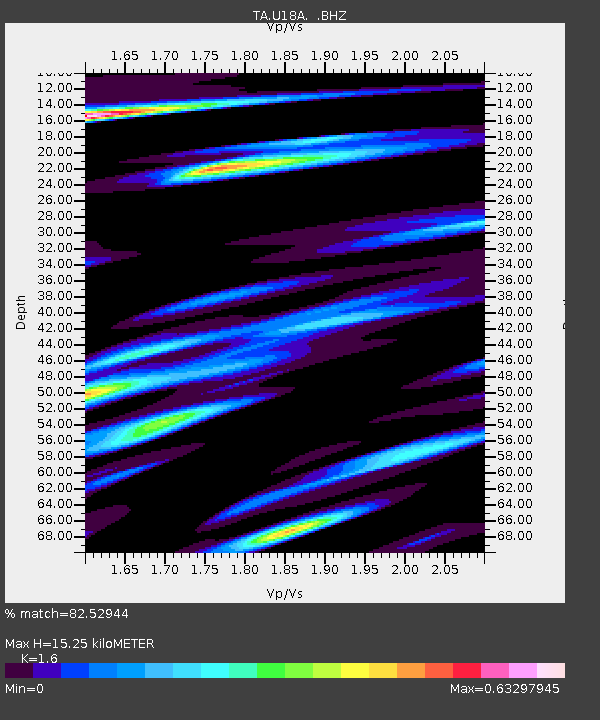
| Estimated Moho Depth: |
15.25 km |
| Estimated Crust Vp/Vs: |
1.60 |
| Assumed Crust Vp: |
6.476 km/s |
| Estimated Crust Vs: |
4.047 km/s |
| Estimated Crust Poisson's Ratio: |
0.18 |
|
| Radial Match: |
82.52944 % |
| Radial Bump: |
331 |
| Transverse Match: |
73.91768 % |
| Transverse Bump: |
339 |
| SOD ConfigId: |
2504 |
| Insert Time: |
2010-03-06 16:23:46.909 +0000 |
| GWidth: |
2.5 |
| Max Bumps: |
400 |
| Tol: |
0.001 |
|

Signal To Noise
| Channel | StoN | STA | LTA |
| TA:U18A: :BHZ:20080819T16:41:45.275002Z | 9.224668 | 7.1067836E-7 | 7.704108E-8 |
| TA:U18A: :BHN:20080819T16:41:45.275002Z | 1.5932913 | 1.7010822E-7 | 1.067653E-7 |
| TA:U18A: :BHE:20080819T16:41:45.275002Z | 2.1289914 | 2.509222E-7 | 1.17859656E-7 |
| Arrivals |
| Ps | 1.5 SECOND |
| PpPs | 5.9 SECOND |
| PsPs/PpSs | 7.4 SECOND |


