You are here: Home > Network List > TA - USArray Transportable Network (new EarthScope stations) Stations List
> Station R18K Karluk, AK, USA > Earthquake Result Viewer
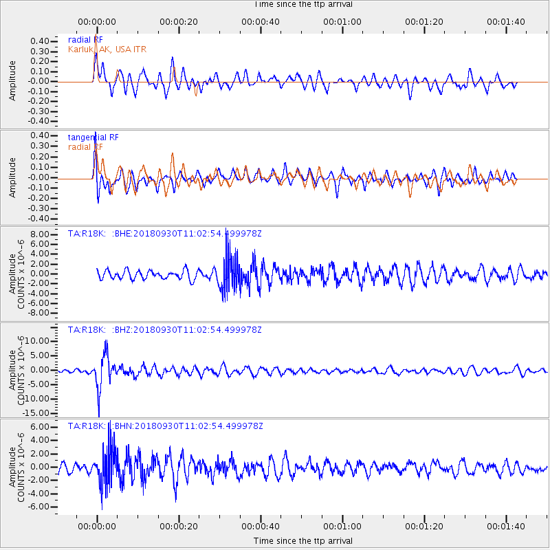
R18K Karluk, AK, USA - Earthquake Result Viewer
*The percent match for this event was below the threshold and hence no stack was calculated.
| Earthquake location: |
Fiji Islands Region |
| Earthquake latitude/longitude: |
-18.4/-178.1 |
| Earthquake time(UTC): |
2018/09/30 (273) 10:52:23 GMT |
| Earthquake Depth: |
551 km |
| Earthquake Magnitude: |
6.6 mww |
| Earthquake Catalog/Contributor: |
NEIC PDE/us |
|
| Network: |
TA USArray Transportable Network (new EarthScope stations) |
| Station: |
R18K Karluk, AK, USA |
| Lat/Lon: |
57.57 N/154.45 W |
| Elevation: |
39 m |
|
| Distance: |
78.2 deg |
| Az: |
12.756 deg |
| Baz: |
202.898 deg |
| Ray Param: |
$rayparam |
*The percent match for this event was below the threshold and hence was not used in the summary stack. |
|
| Radial Match: |
75.305626 % |
| Radial Bump: |
400 |
| Transverse Match: |
60.43566 % |
| Transverse Bump: |
400 |
| SOD ConfigId: |
13570011 |
| Insert Time: |
2019-05-01 09:21:46.646 +0000 |
| GWidth: |
2.5 |
| Max Bumps: |
400 |
| Tol: |
0.001 |
|
Signal To Noise
| Channel | StoN | STA | LTA |
| TA:R18K: :BHZ:20180930T11:02:54.499978Z | 11.84528 | 5.7291563E-6 | 4.8366576E-7 |
| TA:R18K: :BHN:20180930T11:02:54.499978Z | 4.131383 | 2.7245317E-6 | 6.594721E-7 |
| TA:R18K: :BHE:20180930T11:02:54.499978Z | 4.0208035 | 3.494837E-6 | 8.6918874E-7 |
| Arrivals |
| Ps | |
| PpPs | |
| PsPs/PpSs | |


