You are here: Home > Network List > UW - Pacific Northwest Regional Seismic Network Stations List
> Station LTY Liberty (broad-band) > Earthquake Result Viewer
LTY Liberty (broad-band) - Earthquake Result Viewer

| Earthquake location: |
Fiji Islands Region |
| Earthquake latitude/longitude: |
-18.4/-178.1 |
| Earthquake time(UTC): |
2018/09/30 (273) 10:52:23 GMT |
| Earthquake Depth: |
551 km |
| Earthquake Magnitude: |
6.6 mww |
| Earthquake Catalog/Contributor: |
NEIC PDE/us |
|
| Network: |
UW Pacific Northwest Regional Seismic Network |
| Station: |
LTY Liberty (broad-band) |
| Lat/Lon: |
47.26 N/120.66 W |
| Elevation: |
970 m |
|
| Distance: |
83.2 deg |
| Az: |
35.321 deg |
| Baz: |
233.709 deg |
| Ray Param: |
0.044759694 |
| Estimated Moho Depth: |
57.5 km |
| Estimated Crust Vp/Vs: |
1.99 |
| Assumed Crust Vp: |
6.597 km/s |
| Estimated Crust Vs: |
3.319 km/s |
| Estimated Crust Poisson's Ratio: |
0.33 |
|
| Radial Match: |
88.24838 % |
| Radial Bump: |
400 |
| Transverse Match: |
80.339386 % |
| Transverse Bump: |
400 |
| SOD ConfigId: |
13570011 |
| Insert Time: |
2019-05-01 09:23:01.049 +0000 |
| GWidth: |
2.5 |
| Max Bumps: |
400 |
| Tol: |
0.001 |
|
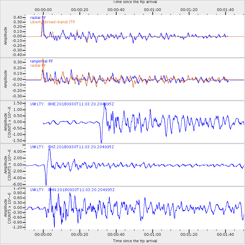
Signal To Noise
| Channel | StoN | STA | LTA |
| UW:LTY: :BHZ:20180930T11:03:20.204995Z | 26.935019 | 2.8310774E-6 | 1.0510768E-7 |
| UW:LTY: :BHN:20180930T11:03:20.204995Z | 3.6017826 | 3.764567E-7 | 1.0451955E-7 |
| UW:LTY: :BHE:20180930T11:03:20.204995Z | 10.171189 | 8.59449E-7 | 8.449838E-8 |
| Arrivals |
| Ps | 8.8 SECOND |
| PpPs | 25 SECOND |
| PsPs/PpSs | 34 SECOND |


