You are here: Home > Network List > TS - TERRAscope (Southern California Seismic Network) Stations List
> Station BAR Barrett Dam, California, USA > Earthquake Result Viewer
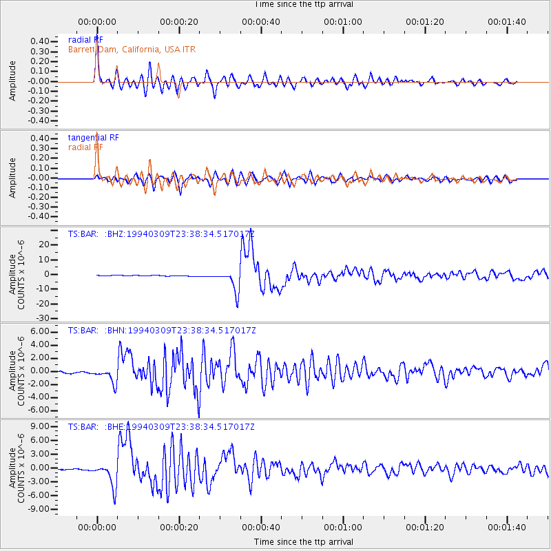
BAR Barrett Dam, California, USA - Earthquake Result Viewer
| Earthquake location: |
Fiji Islands Region |
| Earthquake latitude/longitude: |
-17.8/-178.5 |
| Earthquake time(UTC): |
1994/03/09 (068) 23:28:07 GMT |
| Earthquake Depth: |
564 km |
| Earthquake Magnitude: |
6.6 MB, 7.6 UNKNOWN, 7.6 MW |
| Earthquake Catalog/Contributor: |
WHDF/NEIC |
|
| Network: |
TS TERRAscope (Southern California Seismic Network) |
| Station: |
BAR Barrett Dam, California, USA |
| Lat/Lon: |
32.68 N/116.67 W |
| Elevation: |
548 m |
|
| Distance: |
77.5 deg |
| Az: |
49.596 deg |
| Baz: |
239.364 deg |
| Ray Param: |
0.04851544 |
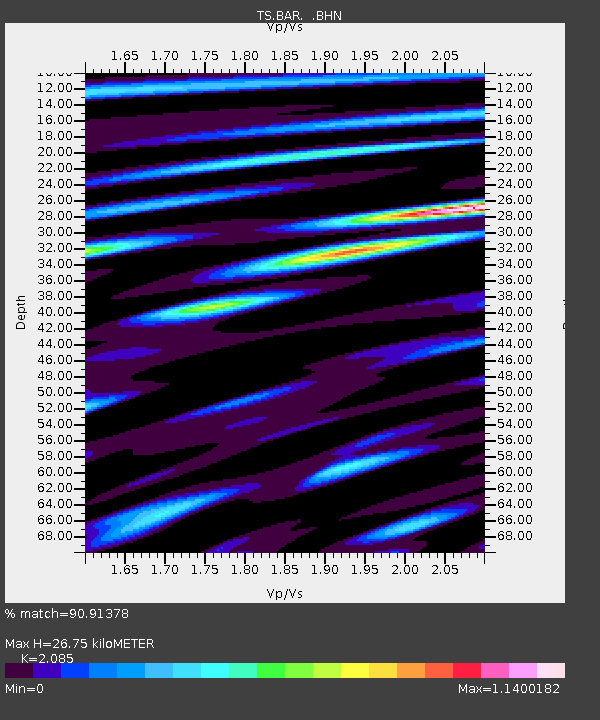
| Estimated Moho Depth: |
26.75 km |
| Estimated Crust Vp/Vs: |
2.09 |
| Assumed Crust Vp: |
6.264 km/s |
| Estimated Crust Vs: |
3.004 km/s |
| Estimated Crust Poisson's Ratio: |
0.35 |
|
| Radial Match: |
90.91378 % |
| Radial Bump: |
400 |
| Transverse Match: |
86.33104 % |
| Transverse Bump: |
400 |
| SOD ConfigId: |
16938 |
| Insert Time: |
2010-02-26 13:57:29.045 +0000 |
| GWidth: |
2.5 |
| Max Bumps: |
400 |
| Tol: |
0.001 |
|
Signal To Noise
| Channel | StoN | STA | LTA |
| TS:BAR: :BHN:19940309T23:38:34.517017Z | 8.569147 | 1.1811605E-6 | 1.3783875E-7 |
| TS:BAR: :BHE:19940309T23:38:34.517017Z | 31.442137 | 2.6737364E-6 | 8.5036724E-8 |
| TS:BAR: :BHZ:19940309T23:38:34.517017Z | 31.703417 | 7.673794E-6 | 2.4204942E-7 |
| Arrivals |
| Ps | 4.7 SECOND |
| PpPs | 13 SECOND |
| PsPs/PpSs | 18 SECOND |


