You are here: Home > Network List > TA - USArray Transportable Network (new EarthScope stations) Stations List
> Station U18A Rough Rock, Chinle, AZ, USA > Earthquake Result Viewer
U18A Rough Rock, Chinle, AZ, USA - Earthquake Result Viewer
| Earthquake location: |
Near West Coast Of Honshu, Japan |
| Earthquake latitude/longitude: |
37.5/138.4 |
| Earthquake time(UTC): |
2007/07/16 (197) 01:13:22 GMT |
| Earthquake Depth: |
12 km |
| Earthquake Magnitude: |
6.5 MB, 6.4 MS, 6.6 MW, 6.5 MW |
| Earthquake Catalog/Contributor: |
WHDF/NEIC |
|
| Network: |
TA USArray Transportable Network (new EarthScope stations) |
| Station: |
U18A Rough Rock, Chinle, AZ, USA |
| Lat/Lon: |
36.42 N/109.87 W |
| Elevation: |
1878 m |
|
| Distance: |
83.0 deg |
| Az: |
49.036 deg |
| Baz: |
311.907 deg |
| Ray Param: |
0.04648624 |
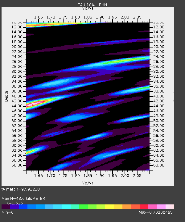
| Estimated Moho Depth: |
43.0 km |
| Estimated Crust Vp/Vs: |
1.62 |
| Assumed Crust Vp: |
6.476 km/s |
| Estimated Crust Vs: |
3.985 km/s |
| Estimated Crust Poisson's Ratio: |
0.20 |
|
| Radial Match: |
97.91218 % |
| Radial Bump: |
353 |
| Transverse Match: |
94.140396 % |
| Transverse Bump: |
400 |
| SOD ConfigId: |
2564 |
| Insert Time: |
2010-03-06 16:24:32.752 +0000 |
| GWidth: |
2.5 |
| Max Bumps: |
400 |
| Tol: |
0.001 |
|

Signal To Noise
| Channel | StoN | STA | LTA |
| TA:U18A: :BHN:20070716T01:25:15.924016Z | 16.466297 | 6.466233E-7 | 3.9269505E-8 |
| TA:U18A: :BHE:20070716T01:25:15.924016Z | 7.3511143 | 6.6793166E-7 | 9.086128E-8 |
| TA:U18A: :BHZ:20070716T01:25:15.924016Z | 81.33158 | 3.0292535E-6 | 3.724572E-8 |
| Arrivals |
| Ps | 4.3 SECOND |
| PpPs | 17 SECOND |
| PsPs/PpSs | 21 SECOND |


