You are here: Home > Network List > TA - USArray Transportable Network (new EarthScope stations) Stations List
> Station U18A Rough Rock, Chinle, AZ, USA > Earthquake Result Viewer
U18A Rough Rock, Chinle, AZ, USA - Earthquake Result Viewer
| Earthquake location: |
Vanuatu Islands |
| Earthquake latitude/longitude: |
-15.4/168.6 |
| Earthquake time(UTC): |
2007/07/15 (196) 09:27:34 GMT |
| Earthquake Depth: |
8.0 km |
| Earthquake Magnitude: |
6.0 MB, 5.8 MS, 6.1 MW, 6.0 MW |
| Earthquake Catalog/Contributor: |
WHDF/NEIC |
|
| Network: |
TA USArray Transportable Network (new EarthScope stations) |
| Station: |
U18A Rough Rock, Chinle, AZ, USA |
| Lat/Lon: |
36.42 N/109.87 W |
| Elevation: |
1878 m |
|
| Distance: |
92.4 deg |
| Az: |
52.985 deg |
| Baz: |
252.732 deg |
| Ray Param: |
0.04146984 |
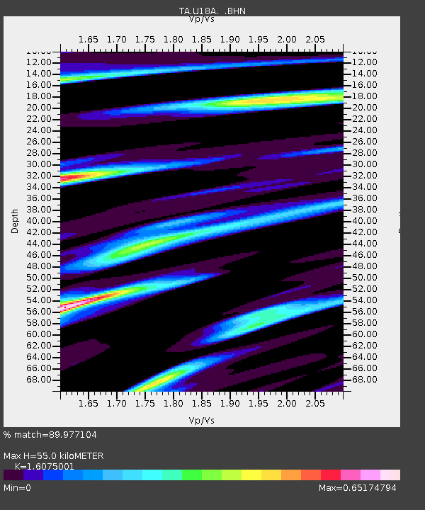
| Estimated Moho Depth: |
55.0 km |
| Estimated Crust Vp/Vs: |
1.61 |
| Assumed Crust Vp: |
6.476 km/s |
| Estimated Crust Vs: |
4.029 km/s |
| Estimated Crust Poisson's Ratio: |
0.18 |
|
| Radial Match: |
89.977104 % |
| Radial Bump: |
395 |
| Transverse Match: |
85.33507 % |
| Transverse Bump: |
400 |
| SOD ConfigId: |
2564 |
| Insert Time: |
2010-03-06 16:24:34.435 +0000 |
| GWidth: |
2.5 |
| Max Bumps: |
400 |
| Tol: |
0.001 |
|

Signal To Noise
| Channel | StoN | STA | LTA |
| TA:U18A: :BHN:20070715T09:40:13.774006Z | 1.9776698 | 1.19086536E-7 | 6.021558E-8 |
| TA:U18A: :BHE:20070715T09:40:13.774006Z | 6.6591525 | 3.3153214E-7 | 4.9785935E-8 |
| TA:U18A: :BHZ:20070715T09:40:13.774006Z | 14.810809 | 9.1494417E-7 | 6.177544E-8 |
| Arrivals |
| Ps | 5.3 SECOND |
| PpPs | 22 SECOND |
| PsPs/PpSs | 27 SECOND |


