You are here: Home > Network List > TA - USArray Transportable Network (new EarthScope stations) Stations List
> Station U18A Rough Rock, Chinle, AZ, USA > Earthquake Result Viewer
U18A Rough Rock, Chinle, AZ, USA - Earthquake Result Viewer
| Earthquake location: |
Kamchatka Peninsula, Russia |
| Earthquake latitude/longitude: |
52.1/157.3 |
| Earthquake time(UTC): |
2007/05/30 (150) 20:22:12 GMT |
| Earthquake Depth: |
116 km |
| Earthquake Magnitude: |
6.4 MB, 6.4 MW, 6.4 MW |
| Earthquake Catalog/Contributor: |
WHDF/NEIC |
|
| Network: |
TA USArray Transportable Network (new EarthScope stations) |
| Station: |
U18A Rough Rock, Chinle, AZ, USA |
| Lat/Lon: |
36.42 N/109.87 W |
| Elevation: |
1878 m |
|
| Distance: |
63.8 deg |
| Az: |
63.836 deg |
| Baz: |
316.698 deg |
| Ray Param: |
0.05898914 |
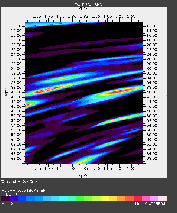
| Estimated Moho Depth: |
45.25 km |
| Estimated Crust Vp/Vs: |
1.60 |
| Assumed Crust Vp: |
6.476 km/s |
| Estimated Crust Vs: |
4.047 km/s |
| Estimated Crust Poisson's Ratio: |
0.18 |
|
| Radial Match: |
90.72564 % |
| Radial Bump: |
335 |
| Transverse Match: |
80.890465 % |
| Transverse Bump: |
374 |
| SOD ConfigId: |
2564 |
| Insert Time: |
2010-03-06 16:24:40.528 +0000 |
| GWidth: |
2.5 |
| Max Bumps: |
400 |
| Tol: |
0.001 |
|

Signal To Noise
| Channel | StoN | STA | LTA |
| TA:U18A: :BHN:20070530T20:32:01.975002Z | 18.77669 | 1.808274E-6 | 9.630419E-8 |
| TA:U18A: :BHE:20070530T20:32:01.975002Z | 9.59517 | 1.4199617E-6 | 1.4798714E-7 |
| TA:U18A: :BHZ:20070530T20:32:01.975002Z | 64.65058 | 4.8004754E-6 | 7.4252625E-8 |
| Arrivals |
| Ps | 4.4 SECOND |
| PpPs | 17 SECOND |
| PsPs/PpSs | 22 SECOND |


