You are here: Home > Network List > TA - USArray Transportable Network (new EarthScope stations) Stations List
> Station U18A Rough Rock, Chinle, AZ, USA > Earthquake Result Viewer
U18A Rough Rock, Chinle, AZ, USA - Earthquake Result Viewer
| Earthquake location: |
Sea Of Okhotsk |
| Earthquake latitude/longitude: |
54.2/154.3 |
| Earthquake time(UTC): |
2008/11/24 (329) 09:02:58 GMT |
| Earthquake Depth: |
492 km |
| Earthquake Magnitude: |
6.5 MB, 7.3 MW, 7.3 MW |
| Earthquake Catalog/Contributor: |
WHDF/NEIC |
|
| Network: |
TA USArray Transportable Network (new EarthScope stations) |
| Station: |
U18A Rough Rock, Chinle, AZ, USA |
| Lat/Lon: |
36.42 N/109.87 W |
| Elevation: |
1878 m |
|
| Distance: |
64.5 deg |
| Az: |
62.747 deg |
| Baz: |
319.645 deg |
| Ray Param: |
0.05712339 |
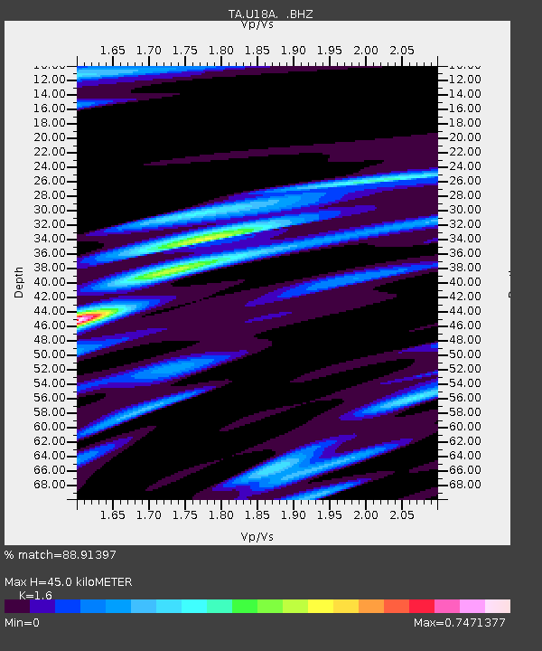
| Estimated Moho Depth: |
45.0 km |
| Estimated Crust Vp/Vs: |
1.60 |
| Assumed Crust Vp: |
6.476 km/s |
| Estimated Crust Vs: |
4.047 km/s |
| Estimated Crust Poisson's Ratio: |
0.18 |
|
| Radial Match: |
88.91397 % |
| Radial Bump: |
318 |
| Transverse Match: |
69.05747 % |
| Transverse Bump: |
400 |
| SOD ConfigId: |
2658 |
| Insert Time: |
2010-03-06 16:24:42.025 +0000 |
| GWidth: |
2.5 |
| Max Bumps: |
400 |
| Tol: |
0.001 |
|

Signal To Noise
| Channel | StoN | STA | LTA |
| TA:U18A: :BHZ:20081124T09:12:15.499014Z | 22.895878 | 4.210933E-6 | 1.8391665E-7 |
| TA:U18A: :BHN:20081124T09:12:15.499014Z | 7.437112 | 1.2945175E-6 | 1.7406185E-7 |
| TA:U18A: :BHE:20081124T09:12:15.499014Z | 3.4686215 | 1.1213947E-6 | 3.2329694E-7 |
| Arrivals |
| Ps | 4.4 SECOND |
| PpPs | 17 SECOND |
| PsPs/PpSs | 22 SECOND |


