You are here: Home > Network List > MM - Myanmar National Seismic Network Stations List
> Station TMU Tamu, Sagaing, Myanmar > Earthquake Result Viewer
TMU Tamu, Sagaing, Myanmar - Earthquake Result Viewer
| Earthquake location: |
Sumba Region, Indonesia |
| Earthquake latitude/longitude: |
-10.5/120.2 |
| Earthquake time(UTC): |
2018/10/01 (274) 23:59:43 GMT |
| Earthquake Depth: |
29 km |
| Earthquake Magnitude: |
6.0 Mww |
| Earthquake Catalog/Contributor: |
NEIC PDE/us |
|
| Network: |
MM Myanmar National Seismic Network |
| Station: |
TMU Tamu, Sagaing, Myanmar |
| Lat/Lon: |
24.23 N/94.30 E |
| Elevation: |
182 m |
|
| Distance: |
42.8 deg |
| Az: |
324.035 deg |
| Baz: |
140.753 deg |
| Ray Param: |
0.07290061 |
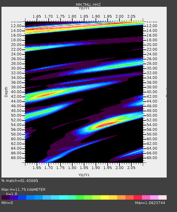
| Estimated Moho Depth: |
11.75 km |
| Estimated Crust Vp/Vs: |
1.80 |
| Assumed Crust Vp: |
6.316 km/s |
| Estimated Crust Vs: |
3.509 km/s |
| Estimated Crust Poisson's Ratio: |
0.28 |
|
| Radial Match: |
81.40865 % |
| Radial Bump: |
400 |
| Transverse Match: |
64.8142 % |
| Transverse Bump: |
400 |
| SOD ConfigId: |
13570011 |
| Insert Time: |
2019-05-01 09:29:26.442 +0000 |
| GWidth: |
2.5 |
| Max Bumps: |
400 |
| Tol: |
0.001 |
|

Signal To Noise
| Channel | StoN | STA | LTA |
| MM:TMU: :HHZ:20181002T00:07:07.737999Z | 9.099132 | 1.0621053E-6 | 1.1672601E-7 |
| MM:TMU: :HHN:20181002T00:07:07.737999Z | 5.4087505 | 5.0419806E-7 | 9.321896E-8 |
| MM:TMU: :HHE:20181002T00:07:07.737999Z | 1.6149454 | 4.2890426E-7 | 2.655844E-7 |
| Arrivals |
| Ps | 1.6 SECOND |
| PpPs | 4.9 SECOND |
| PsPs/PpSs | 6.5 SECOND |


