You are here: Home > Network List > TJ - Tajikistan National Seismic Network Stations List
> Station GARM Garm, Tajikistan > Earthquake Result Viewer
GARM Garm, Tajikistan - Earthquake Result Viewer
| Earthquake location: |
Sumba Region, Indonesia |
| Earthquake latitude/longitude: |
-10.5/120.2 |
| Earthquake time(UTC): |
2018/10/01 (274) 23:59:43 GMT |
| Earthquake Depth: |
29 km |
| Earthquake Magnitude: |
6.0 Mww |
| Earthquake Catalog/Contributor: |
NEIC PDE/us |
|
| Network: |
TJ Tajikistan National Seismic Network |
| Station: |
GARM Garm, Tajikistan |
| Lat/Lon: |
39.00 N/70.32 E |
| Elevation: |
1305 m |
|
| Distance: |
67.7 deg |
| Az: |
319.876 deg |
| Baz: |
125.571 deg |
| Ray Param: |
0.05677109 |
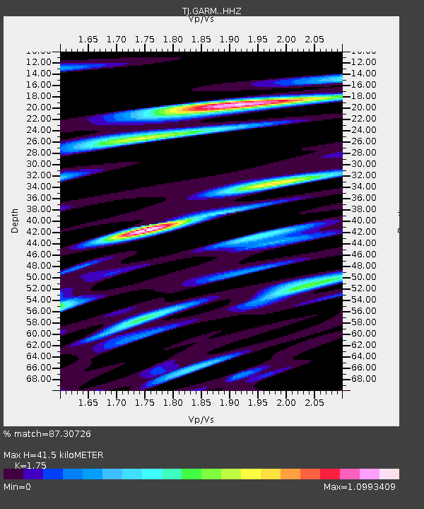
| Estimated Moho Depth: |
41.5 km |
| Estimated Crust Vp/Vs: |
1.75 |
| Assumed Crust Vp: |
6.306 km/s |
| Estimated Crust Vs: |
3.603 km/s |
| Estimated Crust Poisson's Ratio: |
0.26 |
|
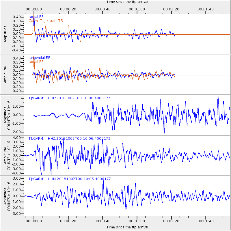
| Radial Match: |
87.30726 % |
| Radial Bump: |
400 |
| Transverse Match: |
83.49264 % |
| Transverse Bump: |
400 |
| SOD ConfigId: |
13570011 |
| Insert Time: |
2019-05-01 09:30:03.175 +0000 |
| GWidth: |
2.5 |
| Max Bumps: |
400 |
| Tol: |
0.001 |
|
Signal To Noise
| Channel | StoN | STA | LTA |
| TJ:GARM: :HHZ:20181002T00:10:06.400017Z | 7.5653768 | 1.8320065E-6 | 2.421567E-7 |
| TJ:GARM: :HHN:20181002T00:10:06.400017Z | 2.9736097 | 5.152053E-7 | 1.7325921E-7 |
| TJ:GARM: :HHE:20181002T00:10:06.400017Z | 5.039356 | 5.901382E-7 | 1.1710588E-7 |
| Arrivals |
| Ps | 5.1 SECOND |
| PpPs | 17 SECOND |
| PsPs/PpSs | 23 SECOND |


