You are here: Home > Network List > TJ - Tajikistan National Seismic Network Stations List
> Station GARM Garm, Tajikistan > Earthquake Result Viewer
GARM Garm, Tajikistan - Earthquake Result Viewer
| Earthquake location: |
Sumba Region, Indonesia |
| Earthquake latitude/longitude: |
-10.5/120.2 |
| Earthquake time(UTC): |
2018/10/02 (275) 00:16:45 GMT |
| Earthquake Depth: |
26 km |
| Earthquake Magnitude: |
5.9 Mww |
| Earthquake Catalog/Contributor: |
NEIC PDE/us |
|
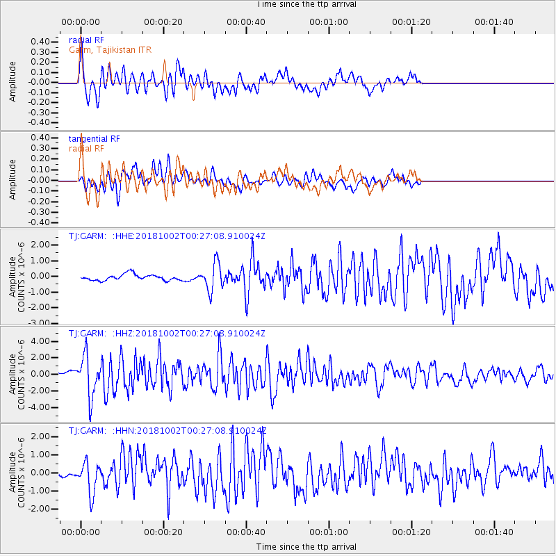
| Network: |
TJ Tajikistan National Seismic Network |
| Station: |
GARM Garm, Tajikistan |
| Lat/Lon: |
39.00 N/70.32 E |
| Elevation: |
1305 m |
|
| Distance: |
67.6 deg |
| Az: |
319.897 deg |
| Baz: |
125.597 deg |
| Ray Param: |
0.056820523 |
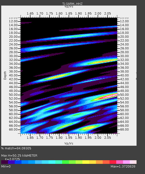
| Estimated Moho Depth: |
50.25 km |
| Estimated Crust Vp/Vs: |
2.07 |
| Assumed Crust Vp: |
6.306 km/s |
| Estimated Crust Vs: |
3.043 km/s |
| Estimated Crust Poisson's Ratio: |
0.35 |
|
| Radial Match: |
84.09305 % |
| Radial Bump: |
400 |
| Transverse Match: |
73.16936 % |
| Transverse Bump: |
400 |
| SOD ConfigId: |
13570011 |
| Insert Time: |
2019-05-01 09:33:06.465 +0000 |
| GWidth: |
2.5 |
| Max Bumps: |
400 |
| Tol: |
0.001 |
|
Signal To Noise
| Channel | StoN | STA | LTA |
| TJ:GARM: :HHZ:20181002T00:27:08.910024Z | 8.226285 | 2.5041047E-6 | 3.0440285E-7 |
| TJ:GARM: :HHN:20181002T00:27:08.910024Z | 3.4895043 | 9.0442404E-7 | 2.591841E-7 |
| TJ:GARM: :HHE:20181002T00:27:08.910024Z | 4.6775546 | 8.97338E-7 | 1.9183912E-7 |
| Arrivals |
| Ps | 8.8 SECOND |
| PpPs | 24 SECOND |
| PsPs/PpSs | 33 SECOND |


